Weather Alerts for Montana
1. High Wind Warning for: Central and Southeast Phillips; Central and Southern Valley; Petroleum; Garfield; Northern Phillips; Southwest Phillips; Northern Valley
2. High Wind Warning for: Daniels; Sheridan; Western Roosevelt; McCone; Richland; Dawson; Prairie; Wibaux; Eastern Roosevelt
3. High Wind Warning for: Eastern Toole and Liberty; Hill County; Northern Blaine County; Western and Central Chouteau County; Bears Paw Mountains and Southern Blaine; Fergus County below 4500ft
4. High Wind Warning for: Red Lodge Foothills
5. Red Flag Warning for: Fort Peck Reservation and Daniels/Roosevelt/Sheridan Counties; Dawson/McCone/Prairie/Richland/Wibaux Counties; Northern Valley and Northern Phillips Counties; The Little Rockies; The Lower Missouri River Breaks including the Charles M Russell National Wildlife Refuge; Southern Petroleum and Southern Garfield Counties
6. Red Flag Warning for: Northern Rosebud/Northern Treasure Counties; Northern Cheyenne Indian Reservation/Ashland Ranger District Custer Natl Forest; Custer County; Sioux Ranger District Custer National Forest
7. Severe Thunderstorm Warning for: Daniels, MT; McCone, MT; Richland, MT; Roosevelt, MT; Sheridan, MT
8. Special Weather Statement for: Central and Southern Valley; Daniels; Sheridan; Western Roosevelt; Garfield; McCone; Richland; Dawson; Northern Valley; Eastern Roosevelt
9. Special Weather Statement for: Northern Blaine County
10. Wind Advisory for: Livingston Area; Beartooth Foothills
11. Winter Storm Warning for: Absaroka/Beartooth Mountains
12. Winter Storm Warning for: Crazy Mountains
13. Winter Storm Warning for: Gallatin and Madison County Mountains and Centennial Mountains
14. Winter Storm Warning for: Judith Basin County and Judith Gap
15. Winter Storm Warning for: Little Belt and Highwood Mountains
16. Winter Weather Advisory for: Bears Paw Mountains and Southern Blaine; Fergus County below 4500ft; Snowy and Judith Mountains
17. Winter Weather Advisory for: Big Belt, Bridger and Castle Mountains
18. Winter Weather Advisory for: Bitterroot/Sapphire Mountains
19. Winter Weather Advisory for: Butte/Blackfoot Region
20. Winter Weather Advisory for: Canyon Ferry Area; Missouri Headwaters; Madison River Valley; Beaverhead and Western Madison below 6000ft
21. Winter Weather Advisory for: Cascade County below 5000ft
22. Winter Weather Advisory for: East Glacier Park Region; Northern High Plains
23. Winter Weather Advisory for: Gallatin Valley
24. Winter Weather Advisory for: Helena Valley
25. Winter Weather Advisory for: Northern Valley
26. Winter Weather Advisory for: Potomac/Seeley Lake Region
27. Winter Weather Advisory for: Southern Rocky Mountain Front; Upper Blackfoot and MacDonald Pass; Gates of the Mountains; Elkhorn and Boulder Mountains; Northwest Beaverhead County; Ruby Mountains and Southern Beaverhead Mountains
28. Winter Weather Advisory for: West Glacier Region
Want more detail? Get the Complete 7 Day and Night Detailed Forecast!
Current U.S. National Radar--Current
The Current National Weather Radar is shown below with a UTC Time (subtract 5 hours from UTC to get Eastern Time).

National Weather Forecast--Current
The Current National Weather Forecast and National Weather Map are shown below.

National Weather Forecast for Tomorrow
Tomorrow National Weather Forecast and Tomorrow National Weather Map are show below.

North America Water Vapor (Moisture)
This map shows recent moisture content over North America. Bright and colored areas show high moisture (ie, clouds); brown indicates very little moisture present; black indicates no moisture.

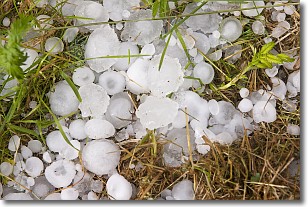
Weather Topic: What is Hail?
Home - Education - Precipitation - Hail
 Next Topic: Hole Punch Clouds
Hail is a form of precipitation which is recognized by large solid balls or
clumps of ice. Hail is created by thunderstorm clouds with strong updrafts of wind.
As the hailstones remain in the updraft, ice is deposited onto them until their
weight becomes heavy enough for them to fall to the earth's surface.
Hail storms can cause significant damage to crops, aircrafts, and man-made structures,
despite the fact that the duration is usually less than ten minutes.
Next Topic: Hole Punch Clouds
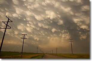
Weather Topic: What are Mammatus Clouds?
Home - Education - Cloud Types - Mammatus Clouds
 Next Topic: Nimbostratus Clouds
A mammatus cloud is a cloud with a unique feature which resembles
a web of pouches hanging along the base of the cloud.
In the United States, mammatus clouds tend to form in the warmer months, commonly
in the Midwest and eastern regions.
While they usually form at the bottom of a cumulonimbis cloud, they can also form
under altostratus, altocumulus, stratocumulus, and cirrus clouds. Mammatus clouds
warn that severe weather is close.
Next Topic: Nimbostratus Clouds
Current conditions powered by WeatherAPI.com


