Weather Alerts for Florida
Rip Current Statement Wind Advisory
1. Flood Advisory for: Palm Beach, FL
2. Flood Watch for: Coastal Indian River; Coastal St. Lucie; Coastal Martin; Inland Indian River; Inland St. Lucie; Inland Martin
3. Flood Watch for: Inland Volusia; Coastal Volusia; Inland Northern Brevard; Mainland Northern Brevard; Northern Brevard Barrier Islands; Inland Southern Brevard; Mainland Southern Brevard; Southern Brevard Barrier Islands
4. Flood Watch for: Metro Palm Beach County; Metro Broward County; Metropolitan Miami Dade; Coastal Palm Beach County; Coastal Broward County; Coastal Miami Dade County
5. High Surf Advisory for: Coastal Indian River; Mainland Southern Brevard; Southern Brevard Barrier Islands
6. High Surf Advisory for: Coastal Nassau; Coastal Duval; Coastal Flagler; Northeast Coastal St. Johns; Southeast Coastal St. Johns; Coastal Glynn; Coastal Camden
7. High Surf Advisory for: Coastal St. Lucie; Coastal Martin
8. High Surf Advisory for: Coastal Volusia
9. High Surf Advisory for: Mainland Northern Brevard; Northern Brevard Barrier Islands
10. Red Flag Warning for: Central Walton; Holmes; Washington; Jackson; Inland Bay; Calhoun; Inland Gulf; Gadsden; Leon; Coastal Bay; Northern Liberty; Southern Liberty; Dougherty; Worth; Turner; Tift; Ben Hill; Irwin; Miller; Baker; Mitchell; Colquitt; Cook; Berrien; Seminole; Decatur; Grady; Thomas; Brooks
11. Red Flag Warning for: South Walton
12. Rip Current Statement for: Coastal Franklin
13. Rip Current Statement for: Coastal Indian River; Mainland Southern Brevard; Southern Brevard Barrier Islands
14. Rip Current Statement for: Coastal Nassau; Coastal Duval; Coastal Flagler; Northeast Coastal St. Johns; Southeast Coastal St. Johns; Coastal Glynn; Coastal Camden
15. Rip Current Statement for: Coastal Palm Beach County; Coastal Broward County; Coastal Miami Dade County
16. Rip Current Statement for: Coastal St. Lucie; Coastal Martin
17. Rip Current Statement for: Coastal Volusia
18. Rip Current Statement for: Mainland Northern Brevard; Northern Brevard Barrier Islands
19. Wind Advisory for: Coastal Indian River; Coastal St. Lucie; Inland Indian River; Inland St. Lucie
20. Wind Advisory for: Coastal Martin; Inland Martin
21. Wind Advisory for: Coastal Nassau; Coastal Duval; Coastal Flagler; Northeast Coastal St. Johns; Southeast Coastal St. Johns
22. Wind Advisory for: Inland Flagler; Eastern Clay; Eastern Putnam; South Central Duval; Northern Inland St. Johns; Southern Inland St. Johns; Western St. Johns
23. Wind Advisory for: Inland Northern Brevard; Mainland Northern Brevard; Northern Brevard Barrier Islands; Inland Southern Brevard; Mainland Southern Brevard; Southern Brevard Barrier Islands
24. Wind Advisory for: Inland Volusia; Coastal Volusia
25. Wind Advisory for: Northern Lake County; Orange; Seminole; Osceola; Southern Lake County
26. Wind Advisory for: Okeechobee
Want more detail? Get the Complete 7 Day and Night Detailed Forecast!
Current U.S. National Radar--Current
The Current National Weather Radar is shown below with a UTC Time (subtract 5 hours from UTC to get Eastern Time).

National Weather Forecast--Current
The Current National Weather Forecast and National Weather Map are shown below.

National Weather Forecast for Tomorrow
Tomorrow National Weather Forecast and Tomorrow National Weather Map are show below.

North America Water Vapor (Moisture)
This map shows recent moisture content over North America. Bright and colored areas show high moisture (ie, clouds); brown indicates very little moisture present; black indicates no moisture.

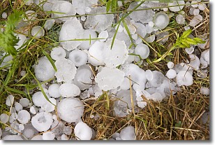
Weather Topic: What is Hail?
Home - Education - Precipitation - Hail
 Next Topic: Hole Punch Clouds
Hail is a form of precipitation which is recognized by large solid balls or
clumps of ice. Hail is created by thunderstorm clouds with strong updrafts of wind.
As the hailstones remain in the updraft, ice is deposited onto them until their
weight becomes heavy enough for them to fall to the earth's surface.
Hail storms can cause significant damage to crops, aircrafts, and man-made structures,
despite the fact that the duration is usually less than ten minutes.
Next Topic: Hole Punch Clouds
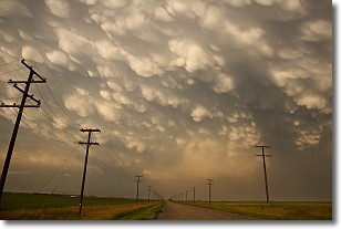
Weather Topic: What are Mammatus Clouds?
Home - Education - Cloud Types - Mammatus Clouds
 Next Topic: Nimbostratus Clouds
A mammatus cloud is a cloud with a unique feature which resembles
a web of pouches hanging along the base of the cloud.
In the United States, mammatus clouds tend to form in the warmer months, commonly
in the Midwest and eastern regions.
While they usually form at the bottom of a cumulonimbis cloud, they can also form
under altostratus, altocumulus, stratocumulus, and cirrus clouds. Mammatus clouds
warn that severe weather is close.
Next Topic: Nimbostratus Clouds
Current conditions powered by WeatherAPI.com


