Weather Alert in Florida
Flood Watch issued August 2 at 3:19PM EDT until August 3 at 2:00AM EDT by NWS Jacksonville FL
AREAS AFFECTED: Baker; Inland Nassau; Eastern Hamilton; Coastal Nassau; Coastal Duval; Western Hamilton; Trout River; Northern Columbia; Western Duval; Coffee; Jeff Davis; Bacon; Appling; Wayne; Atkinson; Pierce; Brantley; Inland Glynn; Coastal Glynn; Echols; Clinch; Inland Camden; Coastal Camden; Northern Ware; Northeastern Charlton; Southern Ware; Western Charlton
DESCRIPTION: * WHAT...Flooding caused by excessive rainfall is possible. * WHERE...Portions of Florida, including the following areas, Baker, Coastal Duval, Coastal Nassau, Eastern Hamilton, Inland Nassau, Northern Columbia, Trout River, Western Duval and Western Hamilton and southeast Georgia, including the following areas, Appling, Atkinson, Bacon, Brantley, Clinch, Coastal Camden, Coastal Glynn, Coffee, Echols, Inland Camden, Inland Glynn, Jeff Davis, Northeastern Charlton, Northern Ware, Pierce, Southern Ware, Wayne and Western Charlton. * WHEN...Until 2 AM EDT Sunday. * IMPACTS...Excessive runoff may result in flooding of rivers, creeks, streams, and other low-lying and flood-prone locations. Flash flooding may occur in poor drainage and urban areas. * ADDITIONAL DETAILS... - http://www.weather.gov/safety/flood
INSTRUCTION: You should monitor later forecasts and be alert for possible Flood Warnings. Those living in areas prone to flooding should be prepared to take action should flooding develop.
Want more detail? Get the Complete 7 Day and Night Detailed Forecast!
Current U.S. National Radar--Current
The Current National Weather Radar is shown below with a UTC Time (subtract 5 hours from UTC to get Eastern Time).

National Weather Forecast--Current
The Current National Weather Forecast and National Weather Map are shown below.

National Weather Forecast for Tomorrow
Tomorrow National Weather Forecast and Tomorrow National Weather Map are show below.

North America Water Vapor (Moisture)
This map shows recent moisture content over North America. Bright and colored areas show high moisture (ie, clouds); brown indicates very little moisture present; black indicates no moisture.

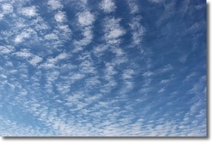
Weather Topic: What are Cirrocumulus Clouds?
Home - Education - Cloud Types - Cirrocumulus Clouds
 Next Topic: Cirrostratus Clouds
Cirrocumulus clouds form at high altitudes (usually around 5 km)
and have distinguishing characteristics displayed in a fine layer of
small cloud patches. These small cloud patches are sometimes referred to as
"cloudlets" in relation to the whole cloud formation.
Cirrocumulus clouds are formed from ice crystals and water droplets. Often, the
water droplets in the cloud freeze into ice crystals and the cloud becomes a
cirrostratus cloud. Because of this common occurrence, cirrocumulus cloud
formations generally pass rapidly.
Next Topic: Cirrostratus Clouds
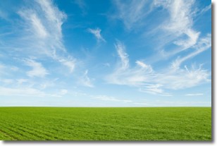
Weather Topic: What are Cirrus Clouds?
Home - Education - Cloud Types - Cirrus Clouds
 Next Topic: Condensation
Cirrus clouds are high-level clouds that occur above 20,000 feet
and are composed mainly of ice crystals.
They are thin and wispy in appearance.
What do they indicate?
They are often the first sign of an approaching storm.
Next Topic: Condensation
Current conditions powered by WeatherAPI.com


