Weather Alert in North Carolina
Beach Hazards Statement issued September 11 at 7:42PM EDT until September 12 at 8:00PM EDT by NWS Wilmington NC
AREAS AFFECTED: Coastal Pender; Coastal New Hanover
DESCRIPTION: * WHAT...For the Beach Hazards Statement, Strong longshore current is expected. For the Coastal Flood Advisory, up to one half foot of inundation above ground level expected in low-lying areas near shorelines and tidal waterways. * WHERE...Coastal Pender and Coastal New Hanover Counties. * WHEN...For the Beach Hazards Statement, from 6 AM EDT Friday through Friday evening. For the Coastal Flood Advisory, from 11 AM to 2 PM EDT Friday. * IMPACTS...Low-lying roads and locations along the Intracoastal Waterway and adjacent tidal creeks may observe minor coastal flooding. Check with local officials for any road closures or impacts. Longshore currents can sweep swimmers and surfers into rip currents, piers, jetties, and other hazardous areas. It may sweep swimmers off their feet, making it difficult to return to shore.
INSTRUCTION: Take the necessary actions to protect flood-prone property. Caution should be used when in or near the water. Check with lifeguards before entering the ocean for possible hazards you may be swept into.
Want more detail? Get the Complete 7 Day and Night Detailed Forecast!
Current U.S. National Radar--Current
The Current National Weather Radar is shown below with a UTC Time (subtract 5 hours from UTC to get Eastern Time).

National Weather Forecast--Current
The Current National Weather Forecast and National Weather Map are shown below.

National Weather Forecast for Tomorrow
Tomorrow National Weather Forecast and Tomorrow National Weather Map are show below.

North America Water Vapor (Moisture)
This map shows recent moisture content over North America. Bright and colored areas show high moisture (ie, clouds); brown indicates very little moisture present; black indicates no moisture.

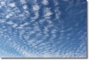
Weather Topic: What are Cirrocumulus Clouds?
Home - Education - Cloud Types - Cirrocumulus Clouds
 Next Topic: Cirrostratus Clouds
Cirrocumulus clouds form at high altitudes (usually around 5 km)
and have distinguishing characteristics displayed in a fine layer of
small cloud patches. These small cloud patches are sometimes referred to as
"cloudlets" in relation to the whole cloud formation.
Cirrocumulus clouds are formed from ice crystals and water droplets. Often, the
water droplets in the cloud freeze into ice crystals and the cloud becomes a
cirrostratus cloud. Because of this common occurrence, cirrocumulus cloud
formations generally pass rapidly.
Next Topic: Cirrostratus Clouds
Weather Topic: What are Cirrus Clouds?
Home - Education - Cloud Types - Cirrus Clouds
 Next Topic: Condensation
Cirrus clouds are high-level clouds that occur above 20,000 feet
and are composed mainly of ice crystals.
They are thin and wispy in appearance.
What do they indicate?
They are often the first sign of an approaching storm.
Next Topic: Condensation
Current conditions powered by WeatherAPI.com


