Weather Alert in Florida
Flood Warning issued September 10 at 8:24PM EDT by NWS Melbourne FL
AREAS AFFECTED: Lake, FL; Volusia, FL
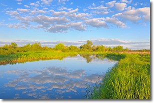
DESCRIPTION: ...The Flood Warning continues for the following rivers in Florida... St Johns River Near Astor affecting Lake and Volusia Counties. .On the Saint Johns River Near Astor, recent rainfall over the basin and increasing northerly winds have caused river levels to slowly rise. The river is now forecast to remain near Moderate flood stage for the next several days. However, any additional rainfall may cause further increases in the river levels. For the St. Johns River...including Astor...Moderate flooding is forecast. Additional information is available at www.weather.gov. The next statement will be issued Thursday morning at 1030 AM EDT. * WHAT...Minor flooding is occurring and moderate flooding is forecast. * WHERE...St Johns River near Astor. * WHEN...Until further notice. * IMPACTS...At 3.0 feet, Water approaches or may enter lowest homes on or near Wildhog Road and nearby canals. Flooding reaches the parking lot of the Juno Trail Apartments. Flooding on portions of Alligator Road and Holiday Road. Lowest lying yards along Blue Creek are flooded. Roads at Astor Landing Campground and Lake Dexter Boat Ramp begin to flood. Water enters lower homes closest to the river on McPherson Lane. * ADDITIONAL DETAILS... - At 7:30 PM EDT Wednesday the stage was 2.9 feet. - Bankfull stage is 2.0 feet. - Recent Activity...The maximum river stage in the 24 hours ending at 7:30 PM EDT Wednesday was 3.0 feet. - Forecast...The river is expected to rise to a crest of 3.0 feet just after midnight tonight, then hold steady near Moderate flood stage. - Flood stage is 2.3 feet. - http://www.weather.gov/safety/flood
INSTRUCTION: N/A
Want more detail? Get the Complete 7 Day and Night Detailed Forecast!
Current U.S. National Radar--Current
The Current National Weather Radar is shown below with a UTC Time (subtract 5 hours from UTC to get Eastern Time).

National Weather Forecast--Current
The Current National Weather Forecast and National Weather Map are shown below.

National Weather Forecast for Tomorrow
Tomorrow National Weather Forecast and Tomorrow National Weather Map are show below.

North America Water Vapor (Moisture)
This map shows recent moisture content over North America. Bright and colored areas show high moisture (ie, clouds); brown indicates very little moisture present; black indicates no moisture.

Weather Topic: What are Stratocumulus Clouds?
Home - Education - Cloud Types - Stratocumulus Clouds
 Next Topic: Stratus Clouds
Stratocumulus clouds are similar to altocumulus clouds in their
fluffy appearance, but have a slightly darker shade due to their additional mass.
A good way to distinguish the two cloud types is to hold your hand out and measure
the size of an individual cloud; if it is the size of your thumb it is generally
an altocumulus cloud, if it is the size of your hand it is generally a
stratocumulus cloud.
It is uncommon for stratocumulus clouds to produce precipitation, but if they do
it is usually a light rain or snow.
Next Topic: Stratus Clouds
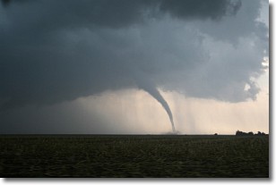
Weather Topic: What are Wall Clouds?
Home - Education - Cloud Types - Wall Clouds
 Next Topic: Altocumulus Clouds
A wall cloud forms underneath the base of a cumulonimbus cloud,
and can be a hotbed for deadly tornadoes.
Wall clouds are formed by air flowing into the cumulonimbus clouds, which can
result in the wall cloud descending from the base of the cumulonimbus cloud, or
rising fractus clouds which join to the base of the storm cloud as the wall cloud
takes shape.
Wall clouds can be very large, and in the Northern Hemisphere they generally
form at the southern edge of cumulonimbus clouds.
Next Topic: Altocumulus Clouds
Current conditions powered by WeatherAPI.com


