Weather Alert in Maryland
Extreme Cold Watch issued February 5 at 1:03PM EST until February 8 at 10:00AM EST by NWS Wakefield VA
AREAS AFFECTED: Dorchester; Wicomico; Somerset; Inland Worcester; Maryland Beaches; Accomack; Northampton
DESCRIPTION: * WHAT...For the High Wind Watch, northwest winds 30 to 40 mph with gusts up to 55 mph possible. For the Extreme Cold Watch, dangerously cold wind chills as low as 10 below possible. * WHERE...In Maryland, Dorchester, Inland Worcester, Maryland Beaches, Somerset, and Wicomico Counties. In Virginia, Northampton and Accomack Counties. * WHEN...For the High Wind Watch, from Saturday morning through Saturday evening. For the Extreme Cold Watch, from Saturday evening through Sunday morning. * IMPACTS...Damaging winds could blow down trees and power lines. Scattered power outages are possible. Travel could be difficult, especially for high profile vehicles. The cold wind chills as low as 10 below zero could result in hypothermia if precautions are not taken.
INSTRUCTION: Monitor the latest forecasts and warnings for updates. Fasten loose objects or shelter objects in a safe location prior to the onset of winds. Dress in layers including a hat, face mask, and gloves if you must go outside. Keep pets indoors as much as possible. Make frequent checks on older family, friends, and neighbors. Ensure portable heaters are used correctly. Do not use generators or grills inside.
Want more detail? Get the Complete 7 Day and Night Detailed Forecast!
Current U.S. National Radar--Current
The Current National Weather Radar is shown below with a UTC Time (subtract 5 hours from UTC to get Eastern Time).

National Weather Forecast--Current
The Current National Weather Forecast and National Weather Map are shown below.

National Weather Forecast for Tomorrow
Tomorrow National Weather Forecast and Tomorrow National Weather Map are show below.

North America Water Vapor (Moisture)
This map shows recent moisture content over North America. Bright and colored areas show high moisture (ie, clouds); brown indicates very little moisture present; black indicates no moisture.

Weather Topic: What is Hail?
Home - Education - Precipitation - Hail
 Next Topic: Hole Punch Clouds
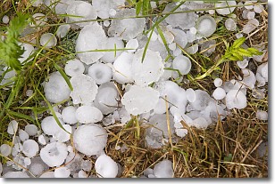
Hail is a form of precipitation which is recognized by large solid balls or
clumps of ice. Hail is created by thunderstorm clouds with strong updrafts of wind.
As the hailstones remain in the updraft, ice is deposited onto them until their
weight becomes heavy enough for them to fall to the earth's surface.
Hail storms can cause significant damage to crops, aircrafts, and man-made structures,
despite the fact that the duration is usually less than ten minutes.
Next Topic: Hole Punch Clouds
Weather Topic: What are Mammatus Clouds?
Home - Education - Cloud Types - Mammatus Clouds
 Next Topic: Nimbostratus Clouds
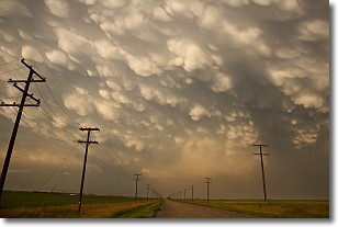
A mammatus cloud is a cloud with a unique feature which resembles
a web of pouches hanging along the base of the cloud.
In the United States, mammatus clouds tend to form in the warmer months, commonly
in the Midwest and eastern regions.
While they usually form at the bottom of a cumulonimbis cloud, they can also form
under altostratus, altocumulus, stratocumulus, and cirrus clouds. Mammatus clouds
warn that severe weather is close.
Next Topic: Nimbostratus Clouds
Current conditions powered by WeatherAPI.com


