Weather Alert in North Carolina
High Wind Watch issued February 5 at 8:57PM EST until February 7 at 7:00PM EST by NWS Greenville-Spartanburg SC
AREAS AFFECTED: Avery; Alexander; Yancey; Mitchell; Buncombe; Southern Jackson; Transylvania; Henderson; Caldwell Mountains; Greater Caldwell; Burke Mountains; Greater Burke; McDowell Mountains; Eastern McDowell; Rutherford Mountains; Greater Rutherford; Polk Mountains; Eastern Polk; Greenville Mountains
DESCRIPTION: * WHAT...Northwest winds 20 to 30 mph with gusts up to 65 mph possible. * WHERE...Portions of western North Carolina and Upstate South Carolina. * WHEN...From Friday evening through Saturday evening. * IMPACTS...Damaging winds could blow down trees and power lines. Widespread power outages are possible. Travel could be difficult, especially for high profile vehicles. * ADDITIONAL DETAILS...The strong winds will result in cold wind chills across the mountains early Saturday morning, and some blowing snow near the Tennessee border.
INSTRUCTION: Be prepared for possible power outages. Take time now to fasten or shelter loose objects in a safe location prior to the onset of high winds. Stay tuned to NOAA Weather Radio or your favorite source of weather information for the latest updates. Additional details can be found at www.weather.gov/gsp.
Want more detail? Get the Complete 7 Day and Night Detailed Forecast!
Current U.S. National Radar--Current
The Current National Weather Radar is shown below with a UTC Time (subtract 5 hours from UTC to get Eastern Time).

National Weather Forecast--Current
The Current National Weather Forecast and National Weather Map are shown below.

National Weather Forecast for Tomorrow
Tomorrow National Weather Forecast and Tomorrow National Weather Map are show below.

North America Water Vapor (Moisture)
This map shows recent moisture content over North America. Bright and colored areas show high moisture (ie, clouds); brown indicates very little moisture present; black indicates no moisture.

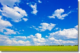
Weather Topic: What are Cumulus Clouds?
Home - Education - Cloud Types - Cumulus Clouds
 Next Topic: Drizzle
Cumulus clouds are fluffy and textured with rounded tops, and
may have flat bottoms. The border of a cumulus cloud
is clearly defined, and can have the appearance of cotton or cauliflower.
Cumulus clouds form at low altitudes (rarely above 2 km) but can grow very tall,
becoming cumulus congestus and possibly the even taller cumulonimbus clouds.
When cumulus clouds become taller, they have a greater chance of producing precipitation.
Next Topic: Drizzle
Weather Topic: What is Evaporation?
Home - Education - Precipitation - Evaporation
 Next Topic: Fog
Evaporation is the process which returns water from the earth
back to the atmosphere, and is another crucial process in the water cycle.
Evaporation is the transformation of liquid into gas, and it happens because
molecules are excited by the application of energy and turn into vapor.
In order for water to evaporate it has to be on the surface of a body of water.
Next Topic: Fog
Current conditions powered by WeatherAPI.com


