Weather Alert in Montana
High Wind Warning issued March 6 at 11:45PM MST until March 8 at 11:00PM MST by NWS Great Falls MT
AREAS AFFECTED: Cascade County below 5000ft; Fergus County below 4500ft
DESCRIPTION: * WHAT...West winds 35 to 50 mph with gusts up to 75 mph expected with isolated gusts up to 85 mph possible. * WHERE...Cascade County below 5000ft and Fergus County below 4500ft. * WHEN...From 3 AM Sunday to midnight MDT Sunday Night. * IMPACTS...Damaging winds will blow down trees and power lines. Power outages are likely. Travel will be difficult to dangerous, especially for high profile vehicles. Blowing dust could significantly reduce visibility at times. * ADDITIONAL DETAILS...The magnitude and duration of the winds will be similar to the December 17th event.
INSTRUCTION: People are urged to secure loose objects that could be blown around or damaged by the wind. If possible, consider delaying travel during the period of highest winds or finding an alternate route.
Want more detail? Get the Complete 7 Day and Night Detailed Forecast!
Current U.S. National Radar--Current
The Current National Weather Radar is shown below with a UTC Time (subtract 5 hours from UTC to get Eastern Time).

National Weather Forecast--Current
The Current National Weather Forecast and National Weather Map are shown below.

National Weather Forecast for Tomorrow
Tomorrow National Weather Forecast and Tomorrow National Weather Map are show below.

North America Water Vapor (Moisture)
This map shows recent moisture content over North America. Bright and colored areas show high moisture (ie, clouds); brown indicates very little moisture present; black indicates no moisture.

Weather Topic: What are Fractus Clouds?
Home - Education - Cloud Types - Fractus Clouds
 Next Topic: Freezing Rain
A fractus cloud (scud) is a fragmented, tattered cloud which has
likely been sheared off of another cloud. They are accessory clouds, meaning they
develop from parent clouds, and are named in a way which describes the original
cloud which contained them.
Fractus clouds which have originated from cumulus clouds are referred to as
cumulus fractus, while fractus clouds which have originated from stratus clouds
are referred to as stratus fractus. Under certain conditions a fractus cloud might
merge with another cloud, or develop into a cumulus cloud, but usually a
fractus cloud seen by itself will dissipate rapidly.
They are often observed on the leading and trailing edges of storm clouds,
and are a display of wind activity.
Next Topic: Freezing Rain
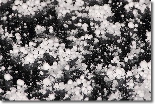
Weather Topic: What is Graupel?
Home - Education - Precipitation - Graupel
 Next Topic: Hail
Graupel is a form of precipitation that is created by atmospheric conditions
which cause supercooled water droplets to contact snow crystals and freeze to
their surface.
Sometimes known as soft hail or snow pellets, graupel is delicate and easily
destroyed by touch. Whereas hail usually falls during severe weather, graupel
doesn't require such conditions to form, and can form in mild precipitation
similar to situations which produce snowfall.
Next Topic: Hail
Current conditions powered by WeatherAPI.com


