Weather Alert in Ohio
Special Weather Statement issued April 29 at 9:38PM EDT by NWS Charleston WV
AREAS AFFECTED: Athens; Washington; Meigs; Mason; Jackson; Wood; Pleasants; Tyler; Roane; Wirt; Calhoun; Ritchie
DESCRIPTION: At 937 PM EDT, Doppler radar was tracking a cluster of strong thunderstorms near Ripley, moving east at 45 mph. HAZARD...Wind gusts up to 40 mph. SOURCE...Radar indicated. IMPACT...Gusty winds could knock down tree limbs and blow around unsecured objects. Locations impacted include... Cherry, Sandyville, Belmont, Maxwell, Mineralwells, Little Hocking, Lucille, Fleming, Syracuse, Macfarlan, Racine, Mount Alto, Peewee, Parkersburg, Hartford City, Willow Island, Walker, Petroleum, Chester, and Marietta. This includes the following highways... Interstate 77 in West Virginia between mile markers 132 and 186. Interstate 77 in Ohio between mile markers 1 and 10. Route 50 in West Virginia between mile markers 1 and 32.
INSTRUCTION: If outdoors, consider seeking shelter inside a building.
Want more detail? Get the Complete 7 Day and Night Detailed Forecast!
Current U.S. National Radar--Current
The Current National Weather Radar is shown below with a UTC Time (subtract 5 hours from UTC to get Eastern Time).

National Weather Forecast--Current
The Current National Weather Forecast and National Weather Map are shown below.

National Weather Forecast for Tomorrow
Tomorrow National Weather Forecast and Tomorrow National Weather Map are show below.

North America Water Vapor (Moisture)
This map shows recent moisture content over North America. Bright and colored areas show high moisture (ie, clouds); brown indicates very little moisture present; black indicates no moisture.

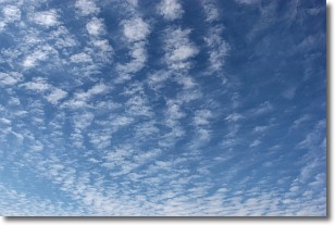
Weather Topic: What are Cirrocumulus Clouds?
Home - Education - Cloud Types - Cirrocumulus Clouds
 Next Topic: Cirrostratus Clouds
Cirrocumulus clouds form at high altitudes (usually around 5 km)
and have distinguishing characteristics displayed in a fine layer of
small cloud patches. These small cloud patches are sometimes referred to as
"cloudlets" in relation to the whole cloud formation.
Cirrocumulus clouds are formed from ice crystals and water droplets. Often, the
water droplets in the cloud freeze into ice crystals and the cloud becomes a
cirrostratus cloud. Because of this common occurrence, cirrocumulus cloud
formations generally pass rapidly.
Next Topic: Cirrostratus Clouds
Weather Topic: What are Cirrus Clouds?
Home - Education - Cloud Types - Cirrus Clouds
 Next Topic: Condensation
Cirrus clouds are high-level clouds that occur above 20,000 feet
and are composed mainly of ice crystals.
They are thin and wispy in appearance.
What do they indicate?
They are often the first sign of an approaching storm.
Next Topic: Condensation
Current conditions powered by WeatherAPI.com


