Weather Alert in Indiana
Flood Warning issued March 3 at 10:47PM EST until March 11 at 8:36AM EDT by NWS Indianapolis IN
AREAS AFFECTED: Daviess, IN; Greene, IN; Knox, IN
DESCRIPTION: ...The Flood Warning continues for the following rivers in Indiana... Haw Creek near Clifford. White River at Elliston. Youngs Creek at Amity. White River at Newberry. ...The Flood Warning is extended for the following rivers in Indiana... East Fork White River at Seymour. .Multiple rounds of rainfall over central Indiana over the next several days are expected to bring at least minor flooding on area rivers and streams. Flooding is expected to develop along portions of the East Fork White and lower White basins over the next 48 hours. Forecast crests issued today include rainfall amounts of 3 to 4 inches over large portions of the East Fork White and lower White basins from this morning through Friday morning, but additional rainfall expected from Friday onward will likely increase crests and lengthen the amount of time in flood. * WHAT...Minor flooding is forecast. * WHERE...White River at Elliston. * WHEN...From Wednesday evening to Wednesday, March 11. * IMPACTS...At 24.0 feet, State Road 157 between Worthington and Bloomfield begins to flood. County Road 175 south of Bloomfield floods. County Road 100 W between CR 110 N and SR 67 (Jefferson Twp), CR 850 N between SR 48 and SR 157 (Jefferson Twp), CR 250 W between SR 54 and CR 250 N (Fairplay Twp), CR 200 W between CR 157 S and CR 260 S (Washington Twp), CR 100 W between CR 100 S and CR 260 S (Washington Twp), and CR 100 W between CR 250 W and the White River affected by high water. * ADDITIONAL DETAILS... - At 8:00 AM EST Tuesday the stage was 8.8 feet. - Forecast...The river is expected to rise above flood stage tomorrow evening to a crest of 24.0 feet Saturday morning. It will then fall below flood stage Tuesday, March 10. - Flood stage is 18.0 feet. - http://www.weather.gov/safety/flood
INSTRUCTION: Stay tuned to further developments by listening to your local radio, television, or NOAA Weather Radio for further information. Be especially cautious at night when it is harder to recognize the dangers of flooding. Additional information is available at www.weather.gov/ind. The next statement should be issued Wednesday afternoon by around 100 PM EST.
Want more detail? Get the Complete 7 Day and Night Detailed Forecast!
Current U.S. National Radar--Current
The Current National Weather Radar is shown below with a UTC Time (subtract 5 hours from UTC to get Eastern Time).

National Weather Forecast--Current
The Current National Weather Forecast and National Weather Map are shown below.

National Weather Forecast for Tomorrow
Tomorrow National Weather Forecast and Tomorrow National Weather Map are show below.

North America Water Vapor (Moisture)
This map shows recent moisture content over North America. Bright and colored areas show high moisture (ie, clouds); brown indicates very little moisture present; black indicates no moisture.

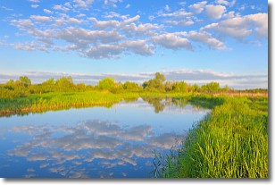
Weather Topic: What are Stratocumulus Clouds?
Home - Education - Cloud Types - Stratocumulus Clouds
 Next Topic: Stratus Clouds
Stratocumulus clouds are similar to altocumulus clouds in their
fluffy appearance, but have a slightly darker shade due to their additional mass.
A good way to distinguish the two cloud types is to hold your hand out and measure
the size of an individual cloud; if it is the size of your thumb it is generally
an altocumulus cloud, if it is the size of your hand it is generally a
stratocumulus cloud.
It is uncommon for stratocumulus clouds to produce precipitation, but if they do
it is usually a light rain or snow.
Next Topic: Stratus Clouds
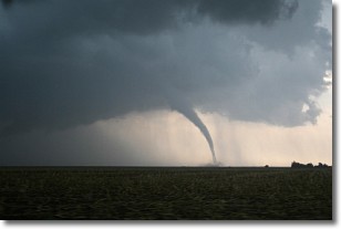
Weather Topic: What are Wall Clouds?
Home - Education - Cloud Types - Wall Clouds
 Next Topic: Altocumulus Clouds
A wall cloud forms underneath the base of a cumulonimbus cloud,
and can be a hotbed for deadly tornadoes.
Wall clouds are formed by air flowing into the cumulonimbus clouds, which can
result in the wall cloud descending from the base of the cumulonimbus cloud, or
rising fractus clouds which join to the base of the storm cloud as the wall cloud
takes shape.
Wall clouds can be very large, and in the Northern Hemisphere they generally
form at the southern edge of cumulonimbus clouds.
Next Topic: Altocumulus Clouds
Current conditions powered by WeatherAPI.com


