Weather Alert in Michigan
Flood Watch issued April 4 at 11:34AM EDT by NWS Grand Rapids MI
AREAS AFFECTED: Ottawa
DESCRIPTION: ...The National Weather Service in Grand Rapids MI has issued a Flood Watch for the following rivers in Michigan... Grand River at Ionia affecting Ionia County. Grand River at Ada affecting Kent County. Grand River at Grand Rapids affecting Kent County. ...Forecast flooding changed from Minor to Moderate severity and increased in duration for the following rivers in Michigan... Grand River at Robinson Township affecting Ottawa County. ...The Flood Watch is replaced by a River Flood Warning for the following rivers in Michigan... Muskegon River at Bridgeton affecting Newaygo County. * WHAT...Flooding is possible. * WHERE...Grand River at Robinson Township. * WHEN...From Monday afternoon until further notice. * IMPACTS...At 15.0 feet, Vanlopik Road is 1 to 2 feet under water. Moderate flooding of several homes on the east end of Vanlopik subdivision occurs. * ADDITIONAL DETAILS... - There is no current observed data. - Forecast...Flood stage may be reached early Monday afternoon. - Flood stage is 13.3 feet. - http://www.weather.gov/safety/flood
INSTRUCTION: Residents and those with interests near the river should monitor rising water levels and be prepared for possible flood warnings. Stay tuned to further developments by listening to your local radio, television, or NOAA Weather Radio for further information. Additional information is available at www.weather.gov/grr.
Want more detail? Get the Complete 7 Day and Night Detailed Forecast!
Current U.S. National Radar--Current
The Current National Weather Radar is shown below with a UTC Time (subtract 5 hours from UTC to get Eastern Time).

National Weather Forecast--Current
The Current National Weather Forecast and National Weather Map are shown below.

National Weather Forecast for Tomorrow
Tomorrow National Weather Forecast and Tomorrow National Weather Map are show below.

North America Water Vapor (Moisture)
This map shows recent moisture content over North America. Bright and colored areas show high moisture (ie, clouds); brown indicates very little moisture present; black indicates no moisture.

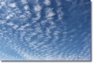
Weather Topic: What are Altocumulus Clouds?
Home - Education - Cloud Types - Altocumulus Clouds
 Next Topic: Altostratus Clouds
Similar to cirrocumulus clouds, altocumulus clouds are
characterized by cloud patches. They are distinguished by larger cloudlets
than cirrocumulus clouds but are still smaller than stratocumulus clouds.
Altocumulus clouds most commonly form in middle altitudes (between 2 and 5 km)
and may resemble, at times, the shape of a flying saucer.
These uncommon formations, called altocumulus lenticularis, are created by uplift
in the atmosphere and are most often seen in close proximity to mountains.
Next Topic: Altostratus Clouds
Weather Topic: What are Cirrocumulus Clouds?
Home - Education - Cloud Types - Cirrocumulus Clouds
 Next Topic: Cirrostratus Clouds
Cirrocumulus clouds form at high altitudes (usually around 5 km)
and have distinguishing characteristics displayed in a fine layer of
small cloud patches. These small cloud patches are sometimes referred to as
"cloudlets" in relation to the whole cloud formation.
Cirrocumulus clouds are formed from ice crystals and water droplets. Often, the
water droplets in the cloud freeze into ice crystals and the cloud becomes a
cirrostratus cloud. Because of this common occurrence, cirrocumulus cloud
formations generally pass rapidly.
Next Topic: Cirrostratus Clouds
Current conditions powered by WeatherAPI.com


