Weather Alert in Montana
High Wind Warning issued March 7 at 11:34AM MST until March 8 at 11:00PM MST by NWS Great Falls MT
AREAS AFFECTED: East Glacier Park Region; Northern High Plains; Eastern Glacier, Western Toole, and Central Pondera; Southern Rocky Mountain Front; Southern High Plains
DESCRIPTION: * WHAT...Westerly winds 40 to 60 mph, with gusts up to 90 mph. Isolated wind gusts over 100 mph are expected along the immediate eastern slopes of the Rocky Mountain Front. * WHERE...The Rocky Mountain Front and adjacent foothills and plains, and Eastern Glacier, Western Toole, and Central Pondera Counties. * WHEN...Until midnight MDT Sunday Night. * IMPACTS...Damaging winds will blow down trees and power lines. Power outages are likely. Travel will be difficult to very dangerous, especially for high profile vehicles.
INSTRUCTION: People are urged to secure loose objects that could be blown around or damaged by the wind. If possible, consider delaying travel during the period of highest winds or finding an alternate route.
Want more detail? Get the Complete 7 Day and Night Detailed Forecast!
Current U.S. National Radar--Current
The Current National Weather Radar is shown below with a UTC Time (subtract 5 hours from UTC to get Eastern Time).

National Weather Forecast--Current
The Current National Weather Forecast and National Weather Map are shown below.

National Weather Forecast for Tomorrow
Tomorrow National Weather Forecast and Tomorrow National Weather Map are show below.

North America Water Vapor (Moisture)
This map shows recent moisture content over North America. Bright and colored areas show high moisture (ie, clouds); brown indicates very little moisture present; black indicates no moisture.

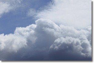
Weather Topic: What are Nimbostratus Clouds?
Home - Education - Cloud Types - Nimbostratus Clouds
 Next Topic: Precipitation
A nimbostratus cloud is similar to a stratus cloud in its formless,
smooth appearance. However, a nimbostratus cloud is darker than a stratus cloud,
because it is thicker.
Unlike a stratus cloud, a nimbostratus cloud typically brings with it the threat
of moderate to heavy precipitation. In some cases, the precipitation may evaporate
before reaching the ground, a phenomenon known as virga.
Next Topic: Precipitation
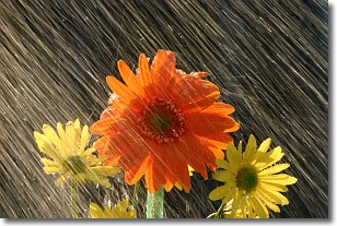
Weather Topic: What is Rain?
Home - Education - Precipitation - Rain
 Next Topic: Shelf Clouds
Precipitation in the form of water droplets is called rain.
Rain generally has a tendency to fall with less intensity over a greater period
of time, and when rainfall is more severe it is usually less sustained.
Rain is the most common form of precipitation and happens with greater frequency
depending on the season and regional influences. Cities have been shown to have
an observable effect on rainfall, due to an effect called the urban heat island.
Compared to upwind, monthly rainfall between twenty and forty miles downwind of
cities is 30% greater.
Next Topic: Shelf Clouds
Current conditions powered by WeatherAPI.com


