Weather Alert in Illinois
Flood Warning issued April 4 at 7:26PM CDT until April 8 at 11:00AM CDT by NWS St Louis MO
AREAS AFFECTED: Fayette, IL
DESCRIPTION: ...The National Weather Service in St Louis has issued a Flood Warning for the following rivers in Illinois... Kaskaskia River at Vandalia. River forecasts are based on observed precipitation and forecast precipitation for the next 24 hours. * WHAT...Minor flooding is forecast. * WHERE...Kaskaskia River at Vandalia. * WHEN...From Sunday afternoon to Wednesday morning. * IMPACTS...At 23.0 feet, Agricultural levee begins to be slightly overtopped. No residences are affected at this level. * ADDITIONAL DETAILS... - At 7:00 PM CDT Saturday the stage was 14.1 feet. - Forecast...The river is expected to rise above flood stage early tomorrow afternoon to a crest of 21.4 feet Monday morning. It will then fall below flood stage early Tuesday morning. - Flood stage is 18.0 feet.
INSTRUCTION: Turn around, don't drown when encountering flooded roads. Most flood deaths occur in vehicles. Rainfall heavier than forecast could cause river levels to rise even higher than predicted. The National Weather Service will monitor this developing situation and issue follow up statements as conditions change. This product, along with additional weather and stream information, is available at https://water.noaa.gov/wfo/lsx
Want more detail? Get the Complete 7 Day and Night Detailed Forecast!
Current U.S. National Radar--Current
The Current National Weather Radar is shown below with a UTC Time (subtract 5 hours from UTC to get Eastern Time).

National Weather Forecast--Current
The Current National Weather Forecast and National Weather Map are shown below.

National Weather Forecast for Tomorrow
Tomorrow National Weather Forecast and Tomorrow National Weather Map are show below.

North America Water Vapor (Moisture)
This map shows recent moisture content over North America. Bright and colored areas show high moisture (ie, clouds); brown indicates very little moisture present; black indicates no moisture.

Weather Topic: What is Graupel?
Home - Education - Precipitation - Graupel
 Next Topic: Hail
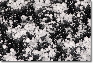
Graupel is a form of precipitation that is created by atmospheric conditions
which cause supercooled water droplets to contact snow crystals and freeze to
their surface.
Sometimes known as soft hail or snow pellets, graupel is delicate and easily
destroyed by touch. Whereas hail usually falls during severe weather, graupel
doesn't require such conditions to form, and can form in mild precipitation
similar to situations which produce snowfall.
Next Topic: Hail
Weather Topic: What are Hole Punch Clouds?
Home - Education - Cloud Types - Hole Punch Clouds
 Next Topic: Mammatus Clouds
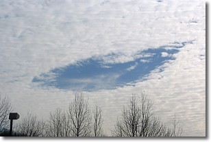
A hole punch cloud is an unusual occurrence when a disk-shaped
hole appears in a cirrostratus, cirrocumulus, or altocumulus cloud.
When part of the cloud forms ice crystals, water droplets in the surrounding area
of the cloud evaporate. The effect of this process produces a large elliptical
gap in the cloud. The hole punch cloud formation is rare, but it is not specific
to any geographic area.
Other names which have been used to describe this phenomena include fallstreak hole,
skypunch, and cloud hole.
Next Topic: Mammatus Clouds
Current conditions powered by WeatherAPI.com


