Weather Alert in Kansas
Dense Fog Advisory issued March 3 at 11:21PM CST until March 4 at 11:00AM CST by NWS Goodland KS
AREAS AFFECTED: Rawlins; Decatur; Norton; Thomas; Sheridan; Graham; Logan; Gove; Hitchcock; Red Willow
DESCRIPTION: * WHAT...Visibility one quarter mile or less in dense fog. Patches of freezing fog may lead to slick surfaces. * WHERE...Portions of northwest and west central Kansas and southwest Nebraska. * WHEN...Until 11 AM CST Wednesday. * IMPACTS...Low visibility could make driving conditions hazardous. Roads, especially bridges and overpasses, will likely become slick and hazardous.
INSTRUCTION: If driving, slow down, use your headlights, and leave plenty of distance ahead of you. Sidewalks, porches, steps, and driveways will become slippery. Pedestrians should use caution when moving about. Freezing fog can create a thin layer of ice on exposed surfaces. The combination of low visibility and slick conditions will make traveling hazardous. If you must travel, use extreme caution!
Want more detail? Get the Complete 7 Day and Night Detailed Forecast!
Current U.S. National Radar--Current
The Current National Weather Radar is shown below with a UTC Time (subtract 5 hours from UTC to get Eastern Time).

National Weather Forecast--Current
The Current National Weather Forecast and National Weather Map are shown below.

National Weather Forecast for Tomorrow
Tomorrow National Weather Forecast and Tomorrow National Weather Map are show below.

North America Water Vapor (Moisture)
This map shows recent moisture content over North America. Bright and colored areas show high moisture (ie, clouds); brown indicates very little moisture present; black indicates no moisture.

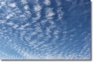
Weather Topic: What are Cirrocumulus Clouds?
Home - Education - Cloud Types - Cirrocumulus Clouds
 Next Topic: Cirrostratus Clouds
Cirrocumulus clouds form at high altitudes (usually around 5 km)
and have distinguishing characteristics displayed in a fine layer of
small cloud patches. These small cloud patches are sometimes referred to as
"cloudlets" in relation to the whole cloud formation.
Cirrocumulus clouds are formed from ice crystals and water droplets. Often, the
water droplets in the cloud freeze into ice crystals and the cloud becomes a
cirrostratus cloud. Because of this common occurrence, cirrocumulus cloud
formations generally pass rapidly.
Next Topic: Cirrostratus Clouds
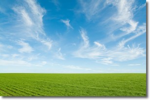
Weather Topic: What are Cirrus Clouds?
Home - Education - Cloud Types - Cirrus Clouds
 Next Topic: Condensation
Cirrus clouds are high-level clouds that occur above 20,000 feet
and are composed mainly of ice crystals.
They are thin and wispy in appearance.
What do they indicate?
They are often the first sign of an approaching storm.
Next Topic: Condensation
Current conditions powered by WeatherAPI.com


