Weather Alert in Texas
Severe Thunderstorm Warning issued April 29 at 6:52PM CDT until April 29 at 7:15PM CDT by NWS Norman OK
AREAS AFFECTED: Archer, TX; Baylor, TX; Foard, TX; Knox, TX; Wichita, TX; Wilbarger, TX
DESCRIPTION: At 651 PM CDT, severe thunderstorms were located along a line extending from 8 miles north of Lake Kemp to 7 miles southwest of Millers Creek Reservoir, moving east at 30 mph. THESE ARE DESTRUCTIVE STORMS FOR SEYMOUR, LAKE KEMP, AND MABELLE. HAZARD...90 mph wind gusts and golf ball size hail. SOURCE...Radar indicated. IMPACT...You are in a life-threatening situation. Flying debris may be deadly to those caught without shelter. Mobile homes will be heavily damaged or destroyed. Homes and businesses will have substantial roof and window damage. Expect extensive tree damage and power outages. Locations impacted include... Seymour, Munday, Megargel, Goree, Red Springs, Lake Diversion, Dundee, Westover, Bomarton, Lake Kemp, Mabelle, Vera, Rhineland, and Lake Kickapoo.
INSTRUCTION: Remain alert for a possible tornado! Tornadoes can develop quickly from severe thunderstorms. This is an EXTREMELY DANGEROUS SITUATION with tornado like wind speeds expected. Mobile homes and high profile vehicles are especially susceptible to winds of this magnitude and may be overturned. These storms have the potential to cause serious injury and significant property damage.
Want more detail? Get the Complete 7 Day and Night Detailed Forecast!
Current U.S. National Radar--Current
The Current National Weather Radar is shown below with a UTC Time (subtract 5 hours from UTC to get Eastern Time).

National Weather Forecast--Current
The Current National Weather Forecast and National Weather Map are shown below.

National Weather Forecast for Tomorrow
Tomorrow National Weather Forecast and Tomorrow National Weather Map are show below.

North America Water Vapor (Moisture)
This map shows recent moisture content over North America. Bright and colored areas show high moisture (ie, clouds); brown indicates very little moisture present; black indicates no moisture.

Weather Topic: What are Fractus Clouds?
Home - Education - Cloud Types - Fractus Clouds
 Next Topic: Freezing Rain
A fractus cloud (scud) is a fragmented, tattered cloud which has
likely been sheared off of another cloud. They are accessory clouds, meaning they
develop from parent clouds, and are named in a way which describes the original
cloud which contained them.
Fractus clouds which have originated from cumulus clouds are referred to as
cumulus fractus, while fractus clouds which have originated from stratus clouds
are referred to as stratus fractus. Under certain conditions a fractus cloud might
merge with another cloud, or develop into a cumulus cloud, but usually a
fractus cloud seen by itself will dissipate rapidly.
They are often observed on the leading and trailing edges of storm clouds,
and are a display of wind activity.
Next Topic: Freezing Rain
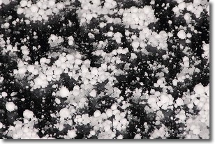
Weather Topic: What is Graupel?
Home - Education - Precipitation - Graupel
 Next Topic: Hail
Graupel is a form of precipitation that is created by atmospheric conditions
which cause supercooled water droplets to contact snow crystals and freeze to
their surface.
Sometimes known as soft hail or snow pellets, graupel is delicate and easily
destroyed by touch. Whereas hail usually falls during severe weather, graupel
doesn't require such conditions to form, and can form in mild precipitation
similar to situations which produce snowfall.
Next Topic: Hail
Current conditions powered by WeatherAPI.com


