Weather Alert in Oregon
Winter Weather Advisory issued March 4 at 3:32AM PST until March 4 at 10:00PM PST by NWS Medford OR
AREAS AFFECTED: South Central Oregon Cascades
DESCRIPTION: * WHAT...Snow expected above 4000 feet. Total snow accumulations 6 to 12 inches. Winds gusting as high as 45 mph over high and exposed terrain. * WHERE...South Central Oregon Cascades, including Diamond Lake and Crater Lake National Park impacting highways 138, 230 and 62. * WHEN...Until 10 PM PST this evening. * IMPACTS...Travel may be difficult and there may be delays in your commute. The hazardous conditions could impact the Wednesday morning and evening commutes. Gusty winds could bring down tree branches. * ADDITIONAL DETAILS...Probability of snow accumulation between 4 AM Wednesday to 4 AM Thursday. Probabilities don't always overlap the hazard's time range. Location >= >= >= >= 4in 6in 8in 12in -------- ---- ---- ---- ---- Crater 100% 94% 71% 36% Lake Visit weather.gov/mfr/winter for additional snow probabilities
INSTRUCTION: Slow down and use caution while traveling. Call 511 or visit tripcheck.com for road information.
Want more detail? Get the Complete 7 Day and Night Detailed Forecast!
Current U.S. National Radar--Current
The Current National Weather Radar is shown below with a UTC Time (subtract 5 hours from UTC to get Eastern Time).

National Weather Forecast--Current
The Current National Weather Forecast and National Weather Map are shown below.

National Weather Forecast for Tomorrow
Tomorrow National Weather Forecast and Tomorrow National Weather Map are show below.

North America Water Vapor (Moisture)
This map shows recent moisture content over North America. Bright and colored areas show high moisture (ie, clouds); brown indicates very little moisture present; black indicates no moisture.

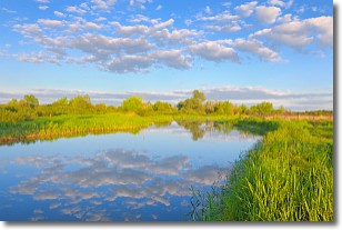
Weather Topic: What are Stratocumulus Clouds?
Home - Education - Cloud Types - Stratocumulus Clouds
 Next Topic: Stratus Clouds
Stratocumulus clouds are similar to altocumulus clouds in their
fluffy appearance, but have a slightly darker shade due to their additional mass.
A good way to distinguish the two cloud types is to hold your hand out and measure
the size of an individual cloud; if it is the size of your thumb it is generally
an altocumulus cloud, if it is the size of your hand it is generally a
stratocumulus cloud.
It is uncommon for stratocumulus clouds to produce precipitation, but if they do
it is usually a light rain or snow.
Next Topic: Stratus Clouds
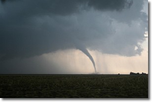
Weather Topic: What are Wall Clouds?
Home - Education - Cloud Types - Wall Clouds
 Next Topic: Altocumulus Clouds
A wall cloud forms underneath the base of a cumulonimbus cloud,
and can be a hotbed for deadly tornadoes.
Wall clouds are formed by air flowing into the cumulonimbus clouds, which can
result in the wall cloud descending from the base of the cumulonimbus cloud, or
rising fractus clouds which join to the base of the storm cloud as the wall cloud
takes shape.
Wall clouds can be very large, and in the Northern Hemisphere they generally
form at the southern edge of cumulonimbus clouds.
Next Topic: Altocumulus Clouds
Current conditions powered by WeatherAPI.com


