Weather Alert in Ohio
Tornado Watch issued March 7 at 1:23PM EST until March 7 at 8:00PM EST by NWS Pittsburgh PA
AREAS AFFECTED: Belmont, OH; Carroll, OH; Columbiana, OH; Coshocton, OH; Guernsey, OH; Harrison, OH; Jefferson, OH; Monroe, OH; Muskingum, OH; Noble, OH; Tuscarawas, OH; Allegheny, PA; Armstrong, PA; Beaver, PA; Butler, PA; Clarion, PA; Fayette, PA; Forest, PA; Greene, PA; Indiana, PA; Jefferson, PA; Lawrence, PA; Mercer, PA; Venango, PA; Washington, PA; Westmoreland, PA; Brooke, WV; Hancock, WV; Marion, WV; Marshall, WV; Monongalia, WV; Ohio, WV; Preston, WV; Wetzel, WV
DESCRIPTION: THE NATIONAL WEATHER SERVICE HAS ISSUED TORNADO WATCH 25 IN EFFECT UNTIL 8 PM EST THIS EVENING FOR THE FOLLOWING AREAS IN OHIO THIS WATCH INCLUDES 11 COUNTIES IN EAST CENTRAL OHIO BELMONT CARROLL COLUMBIANA COSHOCTON GUERNSEY HARRISON JEFFERSON OH MONROE MUSKINGUM NOBLE TUSCARAWAS IN PENNSYLVANIA THIS WATCH INCLUDES 15 COUNTIES IN NORTHWEST PENNSYLVANIA FOREST MERCER VENANGO IN SOUTHWEST PENNSYLVANIA ALLEGHENY FAYETTE GREENE WASHINGTON WESTMORELAND IN WEST CENTRAL PENNSYLVANIA ARMSTRONG BUTLER CLARION INDIANA JEFFERSON PA IN WESTERN PENNSYLVANIA BEAVER LAWRENCE IN WEST VIRGINIA THIS WATCH INCLUDES 8 COUNTIES IN NORTHEAST WEST VIRGINIA PRESTON IN NORTHERN WEST VIRGINIA MARION MONONGALIA WETZEL IN THE NORTHERN PANHANDLE OF WEST VIRGINIA BROOKE HANCOCK MARSHALL OHIO THIS INCLUDES THE CITIES OF ALIQUIPPA, AMBRIDGE, BEAVER FALLS, BROOKVILLE, BUTLER, CADIZ, CALDWELL, CAMBRIDGE, CANONSBURG, CARROLLTON, CLARION, COLUMBIANA, CONNELLSVILLE, COSHOCTON, DOVER, EAST LIVERPOOL, ELLWOOD CITY, FAIRMONT, FOLLANSBEE, FORD CITY, FRANKLIN, GREENSBURG, GROVE CITY, HERMITAGE, INDIANA, KINGWOOD, KITTANNING, LATROBE, MARTINS FERRY, MASONTOWN, MONACA, MORGANTOWN, MOUNDSVILLE, MURRYSVILLE, NEW CASTLE, NEW KENSINGTON, NEW MARTINSVILLE, NEW PHILADELPHIA, OIL CITY, PITTSBURGH METRO AREA, PUNXSUTAWNEY, SALEM, SHARON, ST. CLAIRSVILLE, STEUBENVILLE, TERRA ALTA, TIONESTA, UNIONTOWN, WASHINGTON, WAYNESBURG, WEIRTON, WELLSBURG, WHEELING, WOODSFIELD, AND ZANESVILLE.
INSTRUCTION: N/A
Want more detail? Get the Complete 7 Day and Night Detailed Forecast!
Current U.S. National Radar--Current
The Current National Weather Radar is shown below with a UTC Time (subtract 5 hours from UTC to get Eastern Time).

National Weather Forecast--Current
The Current National Weather Forecast and National Weather Map are shown below.

National Weather Forecast for Tomorrow
Tomorrow National Weather Forecast and Tomorrow National Weather Map are show below.

North America Water Vapor (Moisture)
This map shows recent moisture content over North America. Bright and colored areas show high moisture (ie, clouds); brown indicates very little moisture present; black indicates no moisture.

Weather Topic: What are Altostratus Clouds?
Home - Education - Cloud Types - Altostratus Clouds
 Next Topic: Cirrocumulus Clouds
Altostratus clouds form at mid to high-level altitudes
(between 2 and 7 km) and are created by a warm, stable air mass which causes
water vapor
to condense as it rise through the atmosphere. Usually altostratus clouds are
featureless sheets characterized by a uniform color.
In some cases, wind punching through the cloud formation may give it a waved
appearance, called altostratus undulatus. Altostratus clouds
are commonly seen with other cloud formations accompanying them.
Next Topic: Cirrocumulus Clouds
Weather Topic: What are Cirrostratus Clouds?
Home - Education - Cloud Types - Cirrostratus Clouds
 Next Topic: Cirrus Clouds
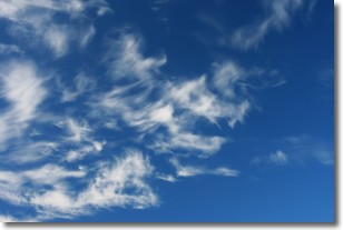
Cirrostratus clouds are high, thin clouds that form above
20,000 feet and are made mostly of ice crystals. They sometimes look like giant
feathers, horse tails, or curls of hair in the sky.
These clouds are pushed by the jet stream and can move at high speeds reaching
100 mph.
What do they indicate?
They indicate that a precipitation is likely within 24 hours.
Next Topic: Cirrus Clouds
Current conditions powered by WeatherAPI.com


