Weather Alert in Oregon
Winter Weather Advisory issued March 3 at 2:53PM PST until March 4 at 10:00PM PST by NWS Medford OR
AREAS AFFECTED: South Central Oregon Cascades
DESCRIPTION: * WHAT...Snow expected above 5000 feet. Total snow accumulations 6 to 10 inches. Winds gusting as high as 40 mph over high and exposed terrain. * WHERE...South Central Oregon Cascades, including Diamond Lake and Crater Lake National Park impacting highways 138, 230 and 62. * WHEN...From 4 AM to 10 PM PST Wednesday. * IMPACTS...Plan on slippery road conditions and delays in your commute. The hazardous conditions could impact the Wednesday morning and evening commutes. * ADDITIONAL DETAILS...Probability of snow accumulation between 4 AM Wednesday to 4 AM Thursday. Probabilities don't always overlap the hazard's time range. Location >= >= >= >= 4in 6in 8in 12in -------- ---- ---- ---- ---- Crater 100% 94% 71% 36% Lake Visit weather.gov/mfr/winter for additional snow probabilities
INSTRUCTION: Slow down and use caution while traveling. Call 511 or visit tripcheck.com for road information.
Want more detail? Get the Complete 7 Day and Night Detailed Forecast!
Current U.S. National Radar--Current
The Current National Weather Radar is shown below with a UTC Time (subtract 5 hours from UTC to get Eastern Time).

National Weather Forecast--Current
The Current National Weather Forecast and National Weather Map are shown below.

National Weather Forecast for Tomorrow
Tomorrow National Weather Forecast and Tomorrow National Weather Map are show below.

North America Water Vapor (Moisture)
This map shows recent moisture content over North America. Bright and colored areas show high moisture (ie, clouds); brown indicates very little moisture present; black indicates no moisture.

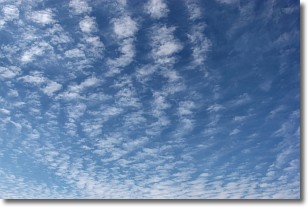
Weather Topic: What are Cirrocumulus Clouds?
Home - Education - Cloud Types - Cirrocumulus Clouds
 Next Topic: Cirrostratus Clouds
Cirrocumulus clouds form at high altitudes (usually around 5 km)
and have distinguishing characteristics displayed in a fine layer of
small cloud patches. These small cloud patches are sometimes referred to as
"cloudlets" in relation to the whole cloud formation.
Cirrocumulus clouds are formed from ice crystals and water droplets. Often, the
water droplets in the cloud freeze into ice crystals and the cloud becomes a
cirrostratus cloud. Because of this common occurrence, cirrocumulus cloud
formations generally pass rapidly.
Next Topic: Cirrostratus Clouds
Weather Topic: What are Cirrus Clouds?
Home - Education - Cloud Types - Cirrus Clouds
 Next Topic: Condensation
Cirrus clouds are high-level clouds that occur above 20,000 feet
and are composed mainly of ice crystals.
They are thin and wispy in appearance.
What do they indicate?
They are often the first sign of an approaching storm.
Next Topic: Condensation
Current conditions powered by WeatherAPI.com


