Weather Alert in Oregon
Winter Weather Advisory issued March 3 at 2:53PM PST until March 4 at 10:00PM PST by NWS Medford OR
AREAS AFFECTED: South Central Oregon Cascades
DESCRIPTION: * WHAT...Snow expected above 5000 feet. Total snow accumulations 6 to 10 inches. Winds gusting as high as 40 mph over high and exposed terrain. * WHERE...South Central Oregon Cascades, including Diamond Lake and Crater Lake National Park impacting highways 138, 230 and 62. * WHEN...From 4 AM to 10 PM PST Wednesday. * IMPACTS...Plan on slippery road conditions and delays in your commute. The hazardous conditions could impact the Wednesday morning and evening commutes. * ADDITIONAL DETAILS...Probability of snow accumulation between 4 AM Wednesday to 4 AM Thursday. Probabilities don't always overlap the hazard's time range. Location >= >= >= >= 4in 6in 8in 12in -------- ---- ---- ---- ---- Crater 100% 94% 71% 36% Lake Visit weather.gov/mfr/winter for additional snow probabilities
INSTRUCTION: Slow down and use caution while traveling. Call 511 or visit tripcheck.com for road information.
Want more detail? Get the Complete 7 Day and Night Detailed Forecast!
Current U.S. National Radar--Current
The Current National Weather Radar is shown below with a UTC Time (subtract 5 hours from UTC to get Eastern Time).

National Weather Forecast--Current
The Current National Weather Forecast and National Weather Map are shown below.

National Weather Forecast for Tomorrow
Tomorrow National Weather Forecast and Tomorrow National Weather Map are show below.

North America Water Vapor (Moisture)
This map shows recent moisture content over North America. Bright and colored areas show high moisture (ie, clouds); brown indicates very little moisture present; black indicates no moisture.

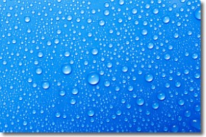
Weather Topic: What is Condensation?
Home - Education - Precipitation - Condensation
 Next Topic: Contrails
Condensation is the process which creates clouds, and therefore
it is a crucial process in the water cycle.
Condensation is the change of matter from a state of gas into a state of liquid,
and it happens because water molecules release heat into the atmosphere and
become organized into a more closely packed structure, what we might see as
water droplets.
Water is always present in the air around us as a vapor, but it's too small for
us to see. When water undergoes the process of condensation it becomes organized
into visible water droplets. You've probably seen condensation happen before on the
surface of a cold drink!
Next Topic: Contrails
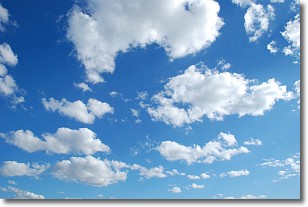
Weather Topic: What are Cumulonimbus Clouds?
Home - Education - Cloud Types - Cumulonimbus Clouds
 Next Topic: Cumulus Clouds
The final form taken by a growing cumulus cloud is the
cumulonimbus cloud, which is very tall and dense.
The tower of a cumulonimbus cloud can soar 23 km into the atmosphere, although
most commonly they stop growing at an altitude of 6 km.
Even small cumulonimbus clouds appear very large in comparison to other cloud types.
They can signal the approach of stormy weather, such as thunderstorms or blizzards.
Next Topic: Cumulus Clouds
Current conditions powered by WeatherAPI.com


