Weather Alert in California
Fire Weather Watch issued June 17 at 1:24PM PDT until June 21 at 12:00AM PDT by NWS Reno NV
AREAS AFFECTED: Southern Mono County; Eastern Lassen County; Northern Sierra Front - Carson City/Douglas/Storey/Southern Washoe/Eastern Lyon/Far Southern Lassen Counties; Southern Sierra Front - Alpine/Northern Mono/Southern Lyon/Western Mineral Counties; West Humboldt Basin - Pershing County; Lahontan Basin - Churchill and Eastern Mineral Counties; Northern Washoe County
DESCRIPTION: The National Weather Service in Reno has issued a Fire Weather Watch for gusty winds and low humidity, which is in effect from Thursday afternoon through Friday evening. * Affected Area...Fire Weather Zone 274 Southern Mono County, Fire Weather Zone 278 Eastern Lassen County, Fire Weather Zone 420 Northern Sierra Front including Carson City, Douglas, Storey, Southern Washoe, Western Lyon, and Far Southern Lassen Counties, Fire Weather Zone 421 Southern Sierra Front including Alpine, Northern Mono, Southern Lyon, and Western Mineral Counties, Fire Weather Zone 423 West Humboldt Basin in Pershing County, Fire Weather Zone 429 Lahontan Basin including Churchill and Eastern Mineral Counties and Fire Weather Zone 458 Northern Washoe County. * Winds...For Thursday, southwest to west 15-20 mph gusting to 30-35 mph. For Friday, southwest to west 20-25 mph gusting to 35-40 mph. Wind prone areas Friday may reach up to 50 mph. * Humidity...For Thursday, minimum humidity 8-15% in the afternoon. For Friday, minimum humidity 5-15% in the afternoon. Limited overnight recoveries Friday morning of 20-30%. * Duration...For Thursday, 3 to 6 hours. For Friday, 4 to 9 hours. * Impacts...The combination of gusty winds and low humidity can cause fire to rapidly grow in size and intensity before first responders can contain them.
INSTRUCTION: Avoid outdoor activities that can cause a spark near dry vegetation, such as yard work, target shooting, or campfires. Follow local fire restrictions. Check weather.gov/reno for updates and livingwithfire.info for preparedness tips.
Want more detail? Get the Complete 7 Day and Night Detailed Forecast!
Current U.S. National Radar--Current
The Current National Weather Radar is shown below with a UTC Time (subtract 5 hours from UTC to get Eastern Time).

National Weather Forecast--Current
The Current National Weather Forecast and National Weather Map are shown below.

National Weather Forecast for Tomorrow
Tomorrow National Weather Forecast and Tomorrow National Weather Map are show below.

North America Water Vapor (Moisture)
This map shows recent moisture content over North America. Bright and colored areas show high moisture (ie, clouds); brown indicates very little moisture present; black indicates no moisture.

Weather Topic: What are Contrails?
Home - Education - Cloud Types - Contrails
 Next Topic: Cumulonimbus Clouds
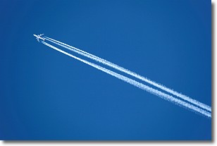
A contrail is an artificial cloud, created by the passing of an
aircraft.
Contrails form because water vapor in the exhaust of aircraft engines is suspended
in the air under certain temperatures and humidity conditions. These contrails
are called exhaust contrails.
Another type of contrail can form due to a temporary reduction in air pressure
moving over the plane's surface, causing condensation.
These are called aerodynamic contrails.
When you can see your breath on a cold day, it is also because of condensation.
The reason contrails last longer than the condensation from your breath is
because the water in contrails freezes into ice particles.
Next Topic: Cumulonimbus Clouds
Weather Topic: What are Cumulus Clouds?
Home - Education - Cloud Types - Cumulus Clouds
 Next Topic: Drizzle
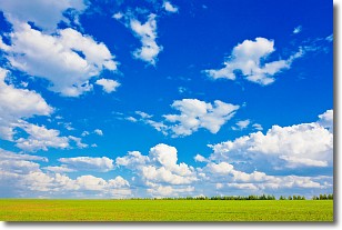
Cumulus clouds are fluffy and textured with rounded tops, and
may have flat bottoms. The border of a cumulus cloud
is clearly defined, and can have the appearance of cotton or cauliflower.
Cumulus clouds form at low altitudes (rarely above 2 km) but can grow very tall,
becoming cumulus congestus and possibly the even taller cumulonimbus clouds.
When cumulus clouds become taller, they have a greater chance of producing precipitation.
Next Topic: Drizzle
Current conditions powered by WeatherAPI.com


