Weather Alert in Oregon
Beach Hazards Statement issued February 5 at 9:44PM PST until February 6 at 10:00PM PST by NWS Medford OR
AREAS AFFECTED: South Central Oregon Coast; Curry County Coast
DESCRIPTION: * WHAT...Moderate risk of sneaker waves expected. * WHERE...Beaches of Curry, Coos, and Douglas counties. * WHEN...From 7 PM PST this evening through Friday evening. * IMPACTS...Sneaker waves can run up significantly farther on beaches than normal, including over rocks and jetties. These waves can suddenly knock people off of their feet and sweep them into the ocean. The waves can also move logs or other objects which could crush or trap anyone caught underneath. * ADDITIONAL DETAILS...While sneaker waves can occur at any time, the greatest risk is on an incoming tide. Please be aware of the tides if venturing out onto the beaches. The high tides will occur roughly between 2 and 3 AM and again around 2 to 3 PM PST Friday. * View the hazard area in detail at https://www.wrh.noaa.gov/map/?wfo=mfr
INSTRUCTION: Avoid climbing on rocks and jetties. Stay away from the ocean and remain out of the water to avoid hazardous conditions.
Want more detail? Get the Complete 7 Day and Night Detailed Forecast!
Current U.S. National Radar--Current
The Current National Weather Radar is shown below with a UTC Time (subtract 5 hours from UTC to get Eastern Time).

National Weather Forecast--Current
The Current National Weather Forecast and National Weather Map are shown below.

National Weather Forecast for Tomorrow
Tomorrow National Weather Forecast and Tomorrow National Weather Map are show below.

North America Water Vapor (Moisture)
This map shows recent moisture content over North America. Bright and colored areas show high moisture (ie, clouds); brown indicates very little moisture present; black indicates no moisture.

Weather Topic: What is Hail?
Home - Education - Precipitation - Hail
 Next Topic: Hole Punch Clouds
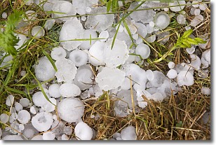
Hail is a form of precipitation which is recognized by large solid balls or
clumps of ice. Hail is created by thunderstorm clouds with strong updrafts of wind.
As the hailstones remain in the updraft, ice is deposited onto them until their
weight becomes heavy enough for them to fall to the earth's surface.
Hail storms can cause significant damage to crops, aircrafts, and man-made structures,
despite the fact that the duration is usually less than ten minutes.
Next Topic: Hole Punch Clouds
Weather Topic: What are Mammatus Clouds?
Home - Education - Cloud Types - Mammatus Clouds
 Next Topic: Nimbostratus Clouds
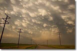
A mammatus cloud is a cloud with a unique feature which resembles
a web of pouches hanging along the base of the cloud.
In the United States, mammatus clouds tend to form in the warmer months, commonly
in the Midwest and eastern regions.
While they usually form at the bottom of a cumulonimbis cloud, they can also form
under altostratus, altocumulus, stratocumulus, and cirrus clouds. Mammatus clouds
warn that severe weather is close.
Next Topic: Nimbostratus Clouds
Current conditions powered by WeatherAPI.com


