Weather Alert in Oregon
Flash Flood Warning issued August 3 at 4:37PM PDT until August 3 at 7:45PM PDT by NWS Boise ID
AREAS AFFECTED: Baker, OR; Malheur, OR
DESCRIPTION: FFWBOI The National Weather Service in Boise has issued a * Flash Flood Warning for... The Cow Valley and Durkee Burn Scar in... South Central Baker County in northeastern Oregon... North Central Malheur County in southeastern Oregon... * Until 745 PM PDT /845 PM MDT/. * At 437 PM PDT /537 PM MDT/, Doppler radar indicated thunderstorms producing heavy rain over the Cow Valley and Durkee Burn Scars. Between 0.5 and 1 inch of rain has fallen. Flash flooding is ongoing or expected to begin shortly. HAZARD...Life threatening flash flooding. Thunderstorms producing flash flooding in and around the Cow Valley and Durkee Burn Scars. SOURCE...Radar. IMPACT...Life threatening flash flooding of areas in and around the Cow Valley and Durkee Burn Scar. * Some locations that will experience flash flooding include... Brogan, Huntington, California Mountain, Brogan Hill Summit, Rye Valley, Malheur Reservoir, Brosman Mountain, Lime, Malheur City, Weatherby and Sugarloaf Butte.
INSTRUCTION: This is a life threatening situation. Heavy rainfall will cause extensive and severe flash flooding of creeks...streams...and ditches in the Cow Valley and Durkee Burn Scar. Severe debris flows can also be anticipated across roads. Roads and driveways may be washed away in places. If you encounter flood waters...climb to safety. Move away from recently burned areas. Life-threatening flooding of creeks, roads and normally dry washes is likely. The heavy rains will likely trigger rockslides, mudslides and debris flows in steep terrain, especially in and around these areas. Please report observed flooding to local emergency services or law enforcement and request they pass this information to the National Weather Service when you can do so safely.
Want more detail? Get the Complete 7 Day and Night Detailed Forecast!
Current U.S. National Radar--Current
The Current National Weather Radar is shown below with a UTC Time (subtract 5 hours from UTC to get Eastern Time).

National Weather Forecast--Current
The Current National Weather Forecast and National Weather Map are shown below.

National Weather Forecast for Tomorrow
Tomorrow National Weather Forecast and Tomorrow National Weather Map are show below.

North America Water Vapor (Moisture)
This map shows recent moisture content over North America. Bright and colored areas show high moisture (ie, clouds); brown indicates very little moisture present; black indicates no moisture.

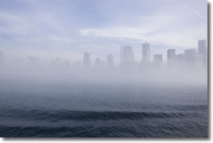
Weather Topic: What is Fog?
Home - Education - Cloud Types - Fog
 Next Topic: Fractus Clouds
Fog is technically a type of stratus cloud, which lies along the
ground and obscures visibility.
It is usually created when humidity in the air condenses into tiny water droplets.
Because of this, some places are more prone to foggy weather, such as regions
close to a body of water.
Fog is similar to mist; both are the appearance of water droplets suspended in
the air, but fog is the term applied to the condition when visibility is less than 1 km.
Next Topic: Fractus Clouds
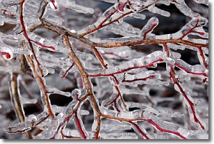
Weather Topic: What is Freezing Rain?
Home - Education - Precipitation - Freezing Rain
 Next Topic: Graupel
Freezing rain is a condition where precipitation which has fallen in the form of
water droplets reaches temperatures which are below freezing and freezes upon
coming into contact
with surface objects. The result of this precipitation is a glaze of ice which
can be damaging to plants and man-made structures. A severe onset of freezing
rain which results in a very thick glaze of ice is known as an ice storm.
Next Topic: Graupel
Current conditions powered by WeatherAPI.com


