Weather Alert in Illinois
Severe Thunderstorm Warning issued April 29 at 2:03PM CDT until April 29 at 2:45PM CDT by NWS Paducah KY
AREAS AFFECTED: Alexander, IL; Franklin, IL; Jackson, IL; Johnson, IL; Perry, IL; Pulaski, IL; Union, IL; Williamson, IL
DESCRIPTION: SVRPAH The National Weather Service in Paducah has issued a * Severe Thunderstorm Warning for... Southeastern Perry County in south central Illinois... Eastern Union County in southern Illinois... Northern Pulaski County in southern Illinois... Western Johnson County in southern Illinois... Williamson County in southern Illinois... Eastern Jackson County in southern Illinois... North central Alexander County in southern Illinois... Franklin County in south central Illinois... * Until 245 PM CDT. * At 202 PM CDT, severe thunderstorms were located along a line extending from Du Quoin to near Carbondale to near Scott City, moving east at 40 mph. HAZARD...60 mph wind gusts. SOURCE...Radar indicated. IMPACT...Expect damage to roofs, siding, and trees. * Locations impacted include... Whiteash, Lake Of Egypt Area, West Frankfort, Spillertown, Buckner, Pittsburg, Hanaford, Crainville, Creal Springs, Zeigler, Bush, Sesser, Ullin, Herrin, Orient, Dowell, Hurst, Buncombe, Colp, and Mill Creek. This includes the following highways... Interstate 24 in Illinois between Mile Markers 1 and 14. Interstate 57 in Illinois between Mile Markers 16 and 80.
INSTRUCTION: For your protection move to an interior room on the lowest floor of a building.
Want more detail? Get the Complete 7 Day and Night Detailed Forecast!
Current U.S. National Radar--Current
The Current National Weather Radar is shown below with a UTC Time (subtract 5 hours from UTC to get Eastern Time).

National Weather Forecast--Current
The Current National Weather Forecast and National Weather Map are shown below.

National Weather Forecast for Tomorrow
Tomorrow National Weather Forecast and Tomorrow National Weather Map are show below.

North America Water Vapor (Moisture)
This map shows recent moisture content over North America. Bright and colored areas show high moisture (ie, clouds); brown indicates very little moisture present; black indicates no moisture.

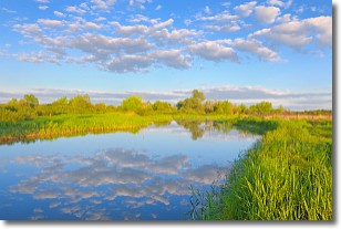
Weather Topic: What are Stratocumulus Clouds?
Home - Education - Cloud Types - Stratocumulus Clouds
 Next Topic: Stratus Clouds
Stratocumulus clouds are similar to altocumulus clouds in their
fluffy appearance, but have a slightly darker shade due to their additional mass.
A good way to distinguish the two cloud types is to hold your hand out and measure
the size of an individual cloud; if it is the size of your thumb it is generally
an altocumulus cloud, if it is the size of your hand it is generally a
stratocumulus cloud.
It is uncommon for stratocumulus clouds to produce precipitation, but if they do
it is usually a light rain or snow.
Next Topic: Stratus Clouds
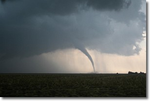
Weather Topic: What are Wall Clouds?
Home - Education - Cloud Types - Wall Clouds
 Next Topic: Altocumulus Clouds
A wall cloud forms underneath the base of a cumulonimbus cloud,
and can be a hotbed for deadly tornadoes.
Wall clouds are formed by air flowing into the cumulonimbus clouds, which can
result in the wall cloud descending from the base of the cumulonimbus cloud, or
rising fractus clouds which join to the base of the storm cloud as the wall cloud
takes shape.
Wall clouds can be very large, and in the Northern Hemisphere they generally
form at the southern edge of cumulonimbus clouds.
Next Topic: Altocumulus Clouds
Current conditions powered by WeatherAPI.com


