Weather Alert in Indiana
Flood Warning issued March 7 at 12:58PM EST by NWS Indianapolis IN
AREAS AFFECTED: Gibson, IN; Knox, IN
DESCRIPTION: ...The Flood Warning continues for the following rivers in Indiana... Illinois... White River at Edwardsport, Spencer, Newberry, Elliston, Hazleton, and Petersburg. Wabash River at Mount Carmel. .Total rainfall amounts of 3 to over 5 inches of rain across much of central and southern Indiana is bringing widespread moderate flooding across the East Fork White and lower White basins and their tributaries. Minor flooding is expected in the lowest reach of the Wabash River at Mount Carmel starting Saturday night. Additional rainfall earlier today and next week could lengthen the amount of time area rivers remain in flood or bring additional rises next week. * WHAT...Moderate flooding is forecast. * WHERE...White River at Hazleton. * WHEN...Until further notice. * IMPACTS...At 24.8 feet, Water begins to come in the street at the corner of West 2nd Street and Brown Street in the town of Hazleton. A six inch water pump is installed at 2nd and Brown Street to keep water off the streets. * ADDITIONAL DETAILS... - There is no current observed data. - Forecast...The river is expected to rise to a crest of 24.4 feet early Wednesday morning. - Flood stage is 16.0 feet. - http://www.weather.gov/safety/flood
INSTRUCTION: Flooding is occurring or is imminent. Most flood related deaths occur in automobiles. Do not attempt to cross water covered bridges, dips, or low water crossings. Never try to cross a flowing stream, even a small one, on foot. To escape rising water find another route over higher ground. Caution is urged when walking near riverbanks. Additional information is available at www.weather.gov/ind. The next statement should be issued late tonight by around 500 AM EDT /400 AM CDT/.
Want more detail? Get the Complete 7 Day and Night Detailed Forecast!
Current U.S. National Radar--Current
The Current National Weather Radar is shown below with a UTC Time (subtract 5 hours from UTC to get Eastern Time).

National Weather Forecast--Current
The Current National Weather Forecast and National Weather Map are shown below.

National Weather Forecast for Tomorrow
Tomorrow National Weather Forecast and Tomorrow National Weather Map are show below.

North America Water Vapor (Moisture)
This map shows recent moisture content over North America. Bright and colored areas show high moisture (ie, clouds); brown indicates very little moisture present; black indicates no moisture.

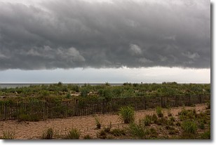
Weather Topic: What are Shelf Clouds?
Home - Education - Cloud Types - Shelf Clouds
 Next Topic: Sleet
A shelf cloud is similar to a wall cloud, but forms at the front
of a storm cloud, instead of at the rear, where wall clouds form.
A shelf cloud is caused by a series of events set into motion by the advancing
storm; first, cool air settles along the ground where precipitation has just fallen.
As the cool air is brought in, the warmer air is displaced, and rises above it,
because it is less dense. When the warmer air reaches the bottom of the storm cloud,
it begins to cool again, and the resulting condensation is a visible shelf cloud.
Next Topic: Sleet
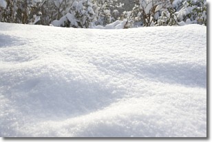
Weather Topic: What is Snow?
Home - Education - Precipitation - Snow
 Next Topic: Stratocumulus Clouds
Snow is precipitation taking the form of ice crystals. Each ice crystal, or snowflake,
has unique characteristics, but all of them grow in a hexagonal structure.
Snowfall can last for sustained periods of time and result in significant buildup
of snow on the ground.
On the earth's surface, snow starts out light and powdery, but as it begins to melt
it tends to become more granular, producing small bits of ice which have the consistency of
sand. After several cycles of melting and freezing, snow can become very dense
and ice-like, commonly known as snow pack.
Next Topic: Stratocumulus Clouds
Current conditions powered by WeatherAPI.com


