Weather Alert in Indiana
Flood Warning issued March 7 at 12:58PM EST until March 14 at 12:00AM EDT by NWS Indianapolis IN
AREAS AFFECTED: Daviess, IN; Gibson, IN; Knox, IN; Pike, IN
DESCRIPTION: ...The Flood Warning continues for the following rivers in Indiana... Illinois... White River at Edwardsport, Spencer, Newberry, Elliston, Hazleton, and Petersburg. Wabash River at Mount Carmel. .Total rainfall amounts of 3 to over 5 inches of rain across much of central and southern Indiana is bringing widespread moderate flooding across the East Fork White and lower White basins and their tributaries. Minor flooding is expected in the lowest reach of the Wabash River at Mount Carmel starting Saturday night. Additional rainfall earlier today and next week could lengthen the amount of time area rivers remain in flood or bring additional rises next week. * WHAT...Minor flooding is occurring and moderate flooding is forecast. * WHERE...White River at Edwardsport. * WHEN...Until Saturday, March 14. * IMPACTS...At 22.9 feet, A 25 foot section of Levee Unit 8 failed at this level on March 6 2011...flooding local roads behind the levee. Flooding not nearly as bad as June 2008 levee failure. * ADDITIONAL DETAILS... - At 7:00 AM EST Saturday /6:00 AM CST Saturday/ the stage was 20.8 feet. - Recent Activity...The maximum river stage in the 24 hours ending at 7:00 AM EST Saturday /6:00 AM CST Saturday/ was 20.8 feet. - Forecast...The river is expected to rise to a crest of 22.1 feet early tomorrow afternoon. It will then fall below flood stage early Friday afternoon. - Flood stage is 15.0 feet. - http://www.weather.gov/safety/flood
INSTRUCTION: Flooding is occurring or is imminent. Most flood related deaths occur in automobiles. Do not attempt to cross water covered bridges, dips, or low water crossings. Never try to cross a flowing stream, even a small one, on foot. To escape rising water find another route over higher ground. Caution is urged when walking near riverbanks. Additional information is available at www.weather.gov/ind. The next statement should be issued late tonight by around 500 AM EDT /400 AM CDT/.
Want more detail? Get the Complete 7 Day and Night Detailed Forecast!
Current U.S. National Radar--Current
The Current National Weather Radar is shown below with a UTC Time (subtract 5 hours from UTC to get Eastern Time).

National Weather Forecast--Current
The Current National Weather Forecast and National Weather Map are shown below.

National Weather Forecast for Tomorrow
Tomorrow National Weather Forecast and Tomorrow National Weather Map are show below.

North America Water Vapor (Moisture)
This map shows recent moisture content over North America. Bright and colored areas show high moisture (ie, clouds); brown indicates very little moisture present; black indicates no moisture.

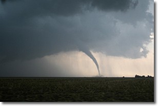
Weather Topic: What are Wall Clouds?
Home - Education - Cloud Types - Wall Clouds
 Next Topic: Altocumulus Clouds
A wall cloud forms underneath the base of a cumulonimbus cloud,
and can be a hotbed for deadly tornadoes.
Wall clouds are formed by air flowing into the cumulonimbus clouds, which can
result in the wall cloud descending from the base of the cumulonimbus cloud, or
rising fractus clouds which join to the base of the storm cloud as the wall cloud
takes shape.
Wall clouds can be very large, and in the Northern Hemisphere they generally
form at the southern edge of cumulonimbus clouds.
Next Topic: Altocumulus Clouds
Weather Topic: What are Altostratus Clouds?
Home - Education - Cloud Types - Altostratus Clouds
 Next Topic: Cirrocumulus Clouds
Altostratus clouds form at mid to high-level altitudes
(between 2 and 7 km) and are created by a warm, stable air mass which causes
water vapor
to condense as it rise through the atmosphere. Usually altostratus clouds are
featureless sheets characterized by a uniform color.
In some cases, wind punching through the cloud formation may give it a waved
appearance, called altostratus undulatus. Altostratus clouds
are commonly seen with other cloud formations accompanying them.
Next Topic: Cirrocumulus Clouds
Current conditions powered by WeatherAPI.com


