Weather Alert in Indiana
Flood Warning issued March 4 at 12:07PM EST until March 9 at 2:00AM EDT by NWS Indianapolis IN
AREAS AFFECTED: Bartholomew, IN; Johnson, IN; Shelby, IN
DESCRIPTION: ...Forecast flooding changed from Minor to Moderate severity and increased in duration for the following rivers in Indiana... Driftwood River near Edinburgh. .Rainfall amounts between two and four inches over parts of central and southern Indiana have led to rises and some flooding on area rivers. Additional rainfall of one to three inches this evening into Thursday morning, with locally higher amounts possible, will bring widespread minor river flooding with pockets of moderate flooding to much of the East Fork White and lower White River basins. * WHAT...Minor flooding is occurring and moderate flooding is forecast. * WHERE...Driftwood River near Edinburgh. * WHEN...From this morning to early Monday morning. * IMPACTS...At 14.9 feet, Extensive flooding along Driftwood River in northern Bartholomew County on March 7, 2011. Double Y Saddle Club area extensively flooded. Water flowing over CR 950N to Club. CR 330W is flooded just south of its intersection with Ohio Ridge Rd. CR 500N west of CR 250W is flooded blocking vehicular access to residences near the river bank. Lowell Public Access site is completely flooded. Water very near several residences and seasonal homes along CR 330W and CR 325W. * ADDITIONAL DETAILS... - At 11:30 AM EST Wednesday the stage was 11.2 feet. - Recent Activity...The maximum river stage in the 24 hours ending at 11:30 AM EST Wednesday was 11.2 feet. - Forecast...The river is expected to rise to a crest of 14.7 feet early Friday morning. It will then fall below flood stage early Sunday afternoon. - Flood stage is 11.0 feet. - http://www.weather.gov/safety/flood
INSTRUCTION: Motorists should not attempt to drive around barricades or drive cars through flooded areas. Additional information is available at www.weather.gov/ind. The next statement should be issued this evening by around 1115 PM EST.
Want more detail? Get the Complete 7 Day and Night Detailed Forecast!
Current U.S. National Radar--Current
The Current National Weather Radar is shown below with a UTC Time (subtract 5 hours from UTC to get Eastern Time).

National Weather Forecast--Current
The Current National Weather Forecast and National Weather Map are shown below.

National Weather Forecast for Tomorrow
Tomorrow National Weather Forecast and Tomorrow National Weather Map are show below.

North America Water Vapor (Moisture)
This map shows recent moisture content over North America. Bright and colored areas show high moisture (ie, clouds); brown indicates very little moisture present; black indicates no moisture.

Weather Topic: What are Altocumulus Clouds?
Home - Education - Cloud Types - Altocumulus Clouds
 Next Topic: Altostratus Clouds
Similar to cirrocumulus clouds, altocumulus clouds are
characterized by cloud patches. They are distinguished by larger cloudlets
than cirrocumulus clouds but are still smaller than stratocumulus clouds.
Altocumulus clouds most commonly form in middle altitudes (between 2 and 5 km)
and may resemble, at times, the shape of a flying saucer.
These uncommon formations, called altocumulus lenticularis, are created by uplift
in the atmosphere and are most often seen in close proximity to mountains.
Next Topic: Altostratus Clouds
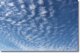
Weather Topic: What are Cirrocumulus Clouds?
Home - Education - Cloud Types - Cirrocumulus Clouds
 Next Topic: Cirrostratus Clouds
Cirrocumulus clouds form at high altitudes (usually around 5 km)
and have distinguishing characteristics displayed in a fine layer of
small cloud patches. These small cloud patches are sometimes referred to as
"cloudlets" in relation to the whole cloud formation.
Cirrocumulus clouds are formed from ice crystals and water droplets. Often, the
water droplets in the cloud freeze into ice crystals and the cloud becomes a
cirrostratus cloud. Because of this common occurrence, cirrocumulus cloud
formations generally pass rapidly.
Next Topic: Cirrostratus Clouds
Current conditions powered by WeatherAPI.com


