Weather Alert in Michigan
Special Weather Statement issued February 5 at 7:41PM EST by NWS Gaylord MI
AREAS AFFECTED: Emmet; Cheboygan; Presque Isle; Leelanau; Antrim; Otsego; Montmorency; Alpena; Benzie; Grand Traverse; Kalkaska; Crawford; Oscoda; Alcona; Manistee; Wexford; Missaukee; Roscommon; Ogemaw; Iosco; Gladwin; Arenac; Western Chippewa; Central Chippewa; Southeast Chippewa; Western Mackinac; Eastern Mackinac; Mackinac Island/Bois Blanc Island; Beaver Island and surrounding islands; Charlevoix
DESCRIPTION: Steadiest snowfall has shifted east of I-75 across northern lower and eastern upper Michigan. In the wake of the snowfall, areas of freezing drizzle have begun to mix in west of I-75 in northern lower Michigan and portions of eastern upper Michigan. This will continue eastward toward the Lake Huron shores of northern lower Michigan this evening, with freezing drizzle potential carrying into the overnight hours until the next round of snow builds into the region from the northwest between roughly 2:00am and 6:00am. As such, a glaze of ice is possible on all untreated surfaces through the evening into tonight. Be cognizant of weather conditions if you must travel this evening into tonight, as slippery surfaces may materialize on area roads, particularly on bridges and overpasses. Remember to increase your following distance in wintry weather, and to take it slow in ice and snow!
INSTRUCTION: N/A
Want more detail? Get the Complete 7 Day and Night Detailed Forecast!
Current U.S. National Radar--Current
The Current National Weather Radar is shown below with a UTC Time (subtract 5 hours from UTC to get Eastern Time).

National Weather Forecast--Current
The Current National Weather Forecast and National Weather Map are shown below.

National Weather Forecast for Tomorrow
Tomorrow National Weather Forecast and Tomorrow National Weather Map are show below.

North America Water Vapor (Moisture)
This map shows recent moisture content over North America. Bright and colored areas show high moisture (ie, clouds); brown indicates very little moisture present; black indicates no moisture.

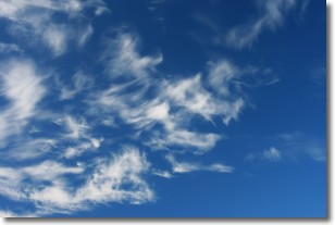
Weather Topic: What are Cirrostratus Clouds?
Home - Education - Cloud Types - Cirrostratus Clouds
 Next Topic: Cirrus Clouds
Cirrostratus clouds are high, thin clouds that form above
20,000 feet and are made mostly of ice crystals. They sometimes look like giant
feathers, horse tails, or curls of hair in the sky.
These clouds are pushed by the jet stream and can move at high speeds reaching
100 mph.
What do they indicate?
They indicate that a precipitation is likely within 24 hours.
Next Topic: Cirrus Clouds
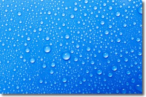
Weather Topic: What is Condensation?
Home - Education - Precipitation - Condensation
 Next Topic: Contrails
Condensation is the process which creates clouds, and therefore
it is a crucial process in the water cycle.
Condensation is the change of matter from a state of gas into a state of liquid,
and it happens because water molecules release heat into the atmosphere and
become organized into a more closely packed structure, what we might see as
water droplets.
Water is always present in the air around us as a vapor, but it's too small for
us to see. When water undergoes the process of condensation it becomes organized
into visible water droplets. You've probably seen condensation happen before on the
surface of a cold drink!
Next Topic: Contrails
Current conditions powered by WeatherAPI.com


