Weather Alert in Indiana
Flood Advisory issued March 4 at 3:52AM EST until March 4 at 8:00AM EST by NWS Wilmington OH
AREAS AFFECTED: Fayette, IN; Franklin, IN; Union, IN
DESCRIPTION: * WHAT...Flooding caused by excessive rainfall continues. * WHERE...Fayette County, Union County, and Franklin County in Indiana. * WHEN...Until 800 AM EST. * IMPACTS...Minor flooding in low-lying and poor drainage areas. * ADDITIONAL DETAILS... - At 349 AM EST, local law enforcement reported minor flooding in the advisory area, with a few roads closed. Between 1.5 and 2.5 inches of rain have fallen. Additional rainfall amounts up to 0.5 inches are possible through 8 AM. - Some locations that may experience flooding include... Laurel, Metamora, Connersville, Brookville, Liberty, West College Corner, Oldenburg, Glenwood, Lake Santee, Salem, Waterloo, Blooming Grove, Columbia, Bunker Hill, Brownsville and Cedar Grove.
INSTRUCTION: Be especially cautious at night when it is harder to recognize the dangers of flooding. To report flooding, go to our website at weather.gov/iln and submit your report via social media, when you can do so safely.
Want more detail? Get the Complete 7 Day and Night Detailed Forecast!
Current U.S. National Radar--Current
The Current National Weather Radar is shown below with a UTC Time (subtract 5 hours from UTC to get Eastern Time).

National Weather Forecast--Current
The Current National Weather Forecast and National Weather Map are shown below.

National Weather Forecast for Tomorrow
Tomorrow National Weather Forecast and Tomorrow National Weather Map are show below.

North America Water Vapor (Moisture)
This map shows recent moisture content over North America. Bright and colored areas show high moisture (ie, clouds); brown indicates very little moisture present; black indicates no moisture.

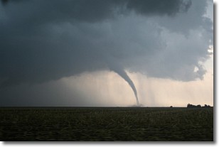
Weather Topic: What are Wall Clouds?
Home - Education - Cloud Types - Wall Clouds
 Next Topic: Altocumulus Clouds
A wall cloud forms underneath the base of a cumulonimbus cloud,
and can be a hotbed for deadly tornadoes.
Wall clouds are formed by air flowing into the cumulonimbus clouds, which can
result in the wall cloud descending from the base of the cumulonimbus cloud, or
rising fractus clouds which join to the base of the storm cloud as the wall cloud
takes shape.
Wall clouds can be very large, and in the Northern Hemisphere they generally
form at the southern edge of cumulonimbus clouds.
Next Topic: Altocumulus Clouds
Weather Topic: What are Altostratus Clouds?
Home - Education - Cloud Types - Altostratus Clouds
 Next Topic: Cirrocumulus Clouds
Altostratus clouds form at mid to high-level altitudes
(between 2 and 7 km) and are created by a warm, stable air mass which causes
water vapor
to condense as it rise through the atmosphere. Usually altostratus clouds are
featureless sheets characterized by a uniform color.
In some cases, wind punching through the cloud formation may give it a waved
appearance, called altostratus undulatus. Altostratus clouds
are commonly seen with other cloud formations accompanying them.
Next Topic: Cirrocumulus Clouds
Current conditions powered by WeatherAPI.com


