Weather Alert in Alaska
Hydrologic Outlook issued September 10 at 10:45AM AKDT by NWS Anchorage AK
AREAS AFFECTED: East Turnagain Arm; Portage; Southern Kenai Mtns; Interior Kenai Peninsula; Turnagain Pass; West Prince William Sound & Whittier; Valdez; Cordova
DESCRIPTION: ESFAFC Multiple rounds of moderate to heavy rainfall are expected along the Prince William Sound Coast through Saturday. This first round of heavier rain will continue through today. A second round is then expected tonight through early Saturday for eastern Prince William Sound before slowly tapering off. Rain may persist through Saturday for Western Prince William Sound. Rainfall * Western Prince William Sound, including Portage and Whittier: 2 to 4 inches of rain is expected through this evening. Steady rain may taper off for a time tonight into early Thursday. However, an additional 2 to 4 inches of rain is possible Thursday through Saturday. * Southern Kenai Peninsula, including Seward: 1 to 2 inches of rain is expected through this evening. Steady rain may taper off for a time tonight into early Thursday. However, an additional 0.75 to 1.5 inches of rain is possible Thursday through Saturday. Higher amounts are likely over higher terrain. * Eastern Turnagain Arm, including Girdwood: 1 to 2 inches of rain is expected through this evening. Steady rain may taper off for a time tonight into early Thursday. However, an additional 1 to 2 inches of rain is possible Thursday through Saturday. Higher amounts are likely over higher terrain. * Eastern Prince William Sound, including Cordova: 1.5 to 3 inches of rain is expected through this evening. Steady rain may taper off for tonight into early Thursday. However, an additional 1.5 to 3 inches of rain is possible Thursday through Saturday. * Valdez: 0.75 to 1.5 inches of rain is expected through this evening. Steady rain may taper off for a time tonight into early Thursday. However, an additional 0.75 to 1.5 inches of rain is possible Thursday through Saturday. Higher amounts are likely over higher terrain. Hydrologic Concerns * Elevated water levels persist on many area streams and rivers. Additional rainfall may bring sharp rises to water levels. Higher than normal water levels may continue through the weekend. * Many lower locations along rivers such as gravel bars and other spots popular for camping and recreating may become inundated with water. * Heavy rain may result in localized ponding in low-lying areas and locations with poor drainage. Next Steps * Residents along area streams as well as river users and recreationists should anticipate higher than normal water levels and are advised to monitor weather and river forecasts. * Reports on river conditions may be sent to the river forecast center by calling 1-800-847-1739.
INSTRUCTION: N/A
Want more detail? Get the Complete 7 Day and Night Detailed Forecast!
Current U.S. National Radar--Current
The Current National Weather Radar is shown below with a UTC Time (subtract 5 hours from UTC to get Eastern Time).

National Weather Forecast--Current
The Current National Weather Forecast and National Weather Map are shown below.

National Weather Forecast for Tomorrow
Tomorrow National Weather Forecast and Tomorrow National Weather Map are show below.

North America Water Vapor (Moisture)
This map shows recent moisture content over North America. Bright and colored areas show high moisture (ie, clouds); brown indicates very little moisture present; black indicates no moisture.

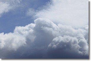
Weather Topic: What are Nimbostratus Clouds?
Home - Education - Cloud Types - Nimbostratus Clouds
 Next Topic: Precipitation
A nimbostratus cloud is similar to a stratus cloud in its formless,
smooth appearance. However, a nimbostratus cloud is darker than a stratus cloud,
because it is thicker.
Unlike a stratus cloud, a nimbostratus cloud typically brings with it the threat
of moderate to heavy precipitation. In some cases, the precipitation may evaporate
before reaching the ground, a phenomenon known as virga.
Next Topic: Precipitation
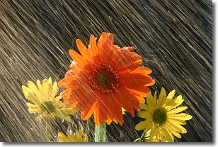
Weather Topic: What is Rain?
Home - Education - Precipitation - Rain
 Next Topic: Shelf Clouds
Precipitation in the form of water droplets is called rain.
Rain generally has a tendency to fall with less intensity over a greater period
of time, and when rainfall is more severe it is usually less sustained.
Rain is the most common form of precipitation and happens with greater frequency
depending on the season and regional influences. Cities have been shown to have
an observable effect on rainfall, due to an effect called the urban heat island.
Compared to upwind, monthly rainfall between twenty and forty miles downwind of
cities is 30% greater.
Next Topic: Shelf Clouds
Current conditions powered by WeatherAPI.com


