Weather Alert in Minnesota
Dense Fog Advisory issued September 11 at 3:37AM CDT until September 11 at 11:00AM CDT by NWS Duluth MN
AREAS AFFECTED: Koochiching; North St. Louis; Northern Cook/Northern Lake; North Itasca; Central St. Louis; Southern Lake/North Shore; Southern Cook/North Shore; North Cass; South Itasca; South Cass; Crow Wing; Northern Aitkin; South Aitkin; Carlton/South St. Louis; Pine; Douglas; Bayfield; Ashland; Iron; Burnett; Washburn; Sawyer; Price
DESCRIPTION: * WHAT...Visibility one quarter mile or less in dense fog. * WHERE...In Minnesota, Crow Wing, Aitkin, Pine, Koochiching, Cass, Itasca, Carlton, St. Louis, Cook and Lake Counties. In Wisconsin, Price, Ashland, Bayfield, Burnett, Douglas, Iron, Sawyer, and Washburn Counties. This includes the Tribal Lands of the northwestern area of the Lac du Flambeau Band, the Grand Portage Reservation, the Bad River Reservation, the Lac Courte Oreilles Reservation, the Fond du Lac Band, the St. Croix Band in Burnett County, the Red Cliff Band, the Mille Lacs Band, East Lake, Hinckley, Lena Lake and, Big Sandy Lake areas and the Bois Forte Band, Lake Vermilion, Deer Creek and, Nett Lake areas. Other locations including Voyageurs National Park, Madeline Island and the Apostle Islands National Lakeshore. The entire Boundary Waters is also included. * WHEN...Until 11 AM CDT this morning. * IMPACTS...Low visibility could make driving conditions hazardous.
INSTRUCTION: If driving, slow down, use your low-beam headlights and fog lights, and leave plenty of distance ahead of you.
Want more detail? Get the Complete 7 Day and Night Detailed Forecast!
Current U.S. National Radar--Current
The Current National Weather Radar is shown below with a UTC Time (subtract 5 hours from UTC to get Eastern Time).

National Weather Forecast--Current
The Current National Weather Forecast and National Weather Map are shown below.

National Weather Forecast for Tomorrow
Tomorrow National Weather Forecast and Tomorrow National Weather Map are show below.

North America Water Vapor (Moisture)
This map shows recent moisture content over North America. Bright and colored areas show high moisture (ie, clouds); brown indicates very little moisture present; black indicates no moisture.

Weather Topic: What is Condensation?
Home - Education - Precipitation - Condensation
 Next Topic: Contrails
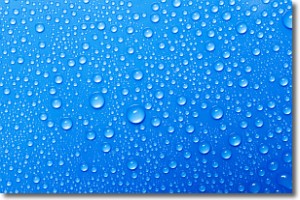
Condensation is the process which creates clouds, and therefore
it is a crucial process in the water cycle.
Condensation is the change of matter from a state of gas into a state of liquid,
and it happens because water molecules release heat into the atmosphere and
become organized into a more closely packed structure, what we might see as
water droplets.
Water is always present in the air around us as a vapor, but it's too small for
us to see. When water undergoes the process of condensation it becomes organized
into visible water droplets. You've probably seen condensation happen before on the
surface of a cold drink!
Next Topic: Contrails
Weather Topic: What are Cumulonimbus Clouds?
Home - Education - Cloud Types - Cumulonimbus Clouds
 Next Topic: Cumulus Clouds
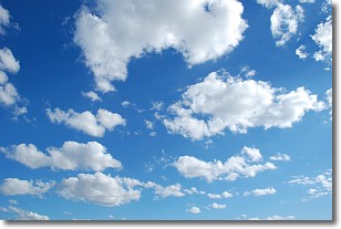
The final form taken by a growing cumulus cloud is the
cumulonimbus cloud, which is very tall and dense.
The tower of a cumulonimbus cloud can soar 23 km into the atmosphere, although
most commonly they stop growing at an altitude of 6 km.
Even small cumulonimbus clouds appear very large in comparison to other cloud types.
They can signal the approach of stormy weather, such as thunderstorms or blizzards.
Next Topic: Cumulus Clouds
Current conditions powered by WeatherAPI.com


