Weather Alert in Minnesota
Flood Warning issued June 18 at 9:36AM CDT until June 22 at 7:00PM CDT by NWS Twin Cities/Chanhassen MN
AREAS AFFECTED: Carver, MN
DESCRIPTION: ...The Flood Warning is extended for the following rivers in Minnesota... Minnesota River at Morton affecting Redwood and Renville Counties. South Fork Crow River below Mayer affecting Carver County. * WHAT...Minor flooding is occurring and minor flooding is forecast. * WHERE...South Fork Crow River below Mayer. * WHEN...Until Sunday evening. * IMPACTS...At 12.0 feet, Flooding affects Mill Avenue from Watertown to the Wright County line; Yancy Avenue between Carver County Road 30 and 78th Street; Vega Avenue between Carver County Road 33 and 94th Street; and the intersection of Union Avenue and 82nd Street. * ADDITIONAL DETAILS... - At 830 AM CDT Wednesday, the stage was 11.1 feet. - Recent Activity...The maximum river stage in the 24 hours ending at 830 AM CDT Wednesday was 11.1 feet. - Forecast...The river is expected to rise to a crest of 11.7 feet early tomorrow afternoon. It will then fall below flood stage early Sunday afternoon. - Flood stage is 11.0 feet. - Flood History...This crest compares to a previous crest of 11.8 feet on 05/28/2011.
INSTRUCTION: Turn around, don't drown when encountering flooded roads. Most flood deaths occur in vehicles. Please report observed flooding to local emergency services or law enforcement and request they pass this information to the National Weather Service when you can do so safely.
Want more detail? Get the Complete 7 Day and Night Detailed Forecast!
Current U.S. National Radar--Current
The Current National Weather Radar is shown below with a UTC Time (subtract 5 hours from UTC to get Eastern Time).

National Weather Forecast--Current
The Current National Weather Forecast and National Weather Map are shown below.

National Weather Forecast for Tomorrow
Tomorrow National Weather Forecast and Tomorrow National Weather Map are show below.

North America Water Vapor (Moisture)
This map shows recent moisture content over North America. Bright and colored areas show high moisture (ie, clouds); brown indicates very little moisture present; black indicates no moisture.

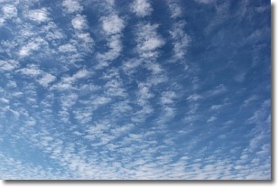
Weather Topic: What are Cirrocumulus Clouds?
Home - Education - Cloud Types - Cirrocumulus Clouds
 Next Topic: Cirrostratus Clouds
Cirrocumulus clouds form at high altitudes (usually around 5 km)
and have distinguishing characteristics displayed in a fine layer of
small cloud patches. These small cloud patches are sometimes referred to as
"cloudlets" in relation to the whole cloud formation.
Cirrocumulus clouds are formed from ice crystals and water droplets. Often, the
water droplets in the cloud freeze into ice crystals and the cloud becomes a
cirrostratus cloud. Because of this common occurrence, cirrocumulus cloud
formations generally pass rapidly.
Next Topic: Cirrostratus Clouds
Weather Topic: What are Cirrus Clouds?
Home - Education - Cloud Types - Cirrus Clouds
 Next Topic: Condensation
Cirrus clouds are high-level clouds that occur above 20,000 feet
and are composed mainly of ice crystals.
They are thin and wispy in appearance.
What do they indicate?
They are often the first sign of an approaching storm.
Next Topic: Condensation
Current conditions powered by WeatherAPI.com


