Weather Alert in North Carolina
Special Weather Statement issued February 5 at 8:16PM EST by NWS Newport/Morehead City NC
AREAS AFFECTED: Beaufort; Mainland Hyde; Jones; Pamlico; Northern Craven; Southern Craven; West Carteret; East Carteret; Inland Onslow; Coastal Onslow
DESCRIPTION: The mix of rain, snow, sleet, and ice pellets, has further dampened the ground near the Crystal Coast this evening resulting in fairly widespread wet spots across portions of Onslow to Carteret County and areas north to Beaufort and mainland Hyde Counties. With temps quickly forecast to fall below freezing tonight, don't think these more widespread wet spots will dry in time, so black ice has become a concern. This threat will last until about 9AM before temps quickly warm above freezing and the black ice threat greatly lowers. Biggest areas of concern will be across bridges, overpasses, and any elevated roadways. Thin sheets of ice, called black ice, may be difficult to see, especially during the pre-dawn hours. They may appear to be wet spots on the road. Motorists will have a difficult time determining which spots are just wet and which are icy. Motorists are advised to use extra caution. Allow ample distance between yourself and other vehicles, to avoid the risk of a collision if slippery conditions are encountered. Allow a little extra time to reach your destination safely.
INSTRUCTION: N/A
Want more detail? Get the Complete 7 Day and Night Detailed Forecast!
Current U.S. National Radar--Current
The Current National Weather Radar is shown below with a UTC Time (subtract 5 hours from UTC to get Eastern Time).

National Weather Forecast--Current
The Current National Weather Forecast and National Weather Map are shown below.

National Weather Forecast for Tomorrow
Tomorrow National Weather Forecast and Tomorrow National Weather Map are show below.

North America Water Vapor (Moisture)
This map shows recent moisture content over North America. Bright and colored areas show high moisture (ie, clouds); brown indicates very little moisture present; black indicates no moisture.

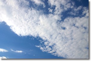
Weather Topic: What are Altocumulus Clouds?
Home - Education - Cloud Types - Altocumulus Clouds
 Next Topic: Altostratus Clouds
Similar to cirrocumulus clouds, altocumulus clouds are
characterized by cloud patches. They are distinguished by larger cloudlets
than cirrocumulus clouds but are still smaller than stratocumulus clouds.
Altocumulus clouds most commonly form in middle altitudes (between 2 and 5 km)
and may resemble, at times, the shape of a flying saucer.
These uncommon formations, called altocumulus lenticularis, are created by uplift
in the atmosphere and are most often seen in close proximity to mountains.
Next Topic: Altostratus Clouds
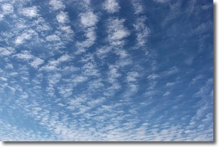
Weather Topic: What are Cirrocumulus Clouds?
Home - Education - Cloud Types - Cirrocumulus Clouds
 Next Topic: Cirrostratus Clouds
Cirrocumulus clouds form at high altitudes (usually around 5 km)
and have distinguishing characteristics displayed in a fine layer of
small cloud patches. These small cloud patches are sometimes referred to as
"cloudlets" in relation to the whole cloud formation.
Cirrocumulus clouds are formed from ice crystals and water droplets. Often, the
water droplets in the cloud freeze into ice crystals and the cloud becomes a
cirrostratus cloud. Because of this common occurrence, cirrocumulus cloud
formations generally pass rapidly.
Next Topic: Cirrostratus Clouds
Current conditions powered by WeatherAPI.com


