Weather Alert in North Carolina
Special Weather Statement issued February 5 at 8:16PM EST by NWS Newport/Morehead City NC
AREAS AFFECTED: Beaufort; Mainland Hyde; Jones; Pamlico; Northern Craven; Southern Craven; West Carteret; East Carteret; Inland Onslow; Coastal Onslow
DESCRIPTION: The mix of rain, snow, sleet, and ice pellets, has further dampened the ground near the Crystal Coast this evening resulting in fairly widespread wet spots across portions of Onslow to Carteret County and areas north to Beaufort and mainland Hyde Counties. With temps quickly forecast to fall below freezing tonight, don't think these more widespread wet spots will dry in time, so black ice has become a concern. This threat will last until about 9AM before temps quickly warm above freezing and the black ice threat greatly lowers. Biggest areas of concern will be across bridges, overpasses, and any elevated roadways. Thin sheets of ice, called black ice, may be difficult to see, especially during the pre-dawn hours. They may appear to be wet spots on the road. Motorists will have a difficult time determining which spots are just wet and which are icy. Motorists are advised to use extra caution. Allow ample distance between yourself and other vehicles, to avoid the risk of a collision if slippery conditions are encountered. Allow a little extra time to reach your destination safely.
INSTRUCTION: N/A
Want more detail? Get the Complete 7 Day and Night Detailed Forecast!
Current U.S. National Radar--Current
The Current National Weather Radar is shown below with a UTC Time (subtract 5 hours from UTC to get Eastern Time).

National Weather Forecast--Current
The Current National Weather Forecast and National Weather Map are shown below.

National Weather Forecast for Tomorrow
Tomorrow National Weather Forecast and Tomorrow National Weather Map are show below.

North America Water Vapor (Moisture)
This map shows recent moisture content over North America. Bright and colored areas show high moisture (ie, clouds); brown indicates very little moisture present; black indicates no moisture.

Weather Topic: What is Snow?
Home - Education - Precipitation - Snow
 Next Topic: Stratocumulus Clouds
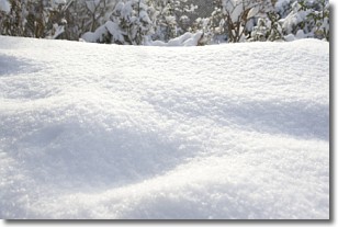
Snow is precipitation taking the form of ice crystals. Each ice crystal, or snowflake,
has unique characteristics, but all of them grow in a hexagonal structure.
Snowfall can last for sustained periods of time and result in significant buildup
of snow on the ground.
On the earth's surface, snow starts out light and powdery, but as it begins to melt
it tends to become more granular, producing small bits of ice which have the consistency of
sand. After several cycles of melting and freezing, snow can become very dense
and ice-like, commonly known as snow pack.
Next Topic: Stratocumulus Clouds
Weather Topic: What are Stratus Clouds?
Home - Education - Cloud Types - Stratus Clouds
 Next Topic: Wall Clouds
Stratus clouds are similar to altostratus clouds, but form at a
lower altitude and are identified by their fog-like appearance, lacking the
distinguishing features of most clouds.
Stratus clouds are wider than most clouds, and their base has a smooth, uniform
look which is lighter in color than a nimbostratus cloud.
The presence of a stratus cloud indicates the possibility of minor precipitation,
such as drizzle, but heavier precipitation does not typically arrive in the form
of a stratus cloud.
Next Topic: Wall Clouds
Current conditions powered by WeatherAPI.com


