Weather Alert in Illinois
Flood Warning issued April 29 at 9:43AM CDT until May 7 at 4:36AM CDT by NWS St Louis MO
AREAS AFFECTED: Clinton, IL
DESCRIPTION: ...The Flood Warning continues for the following rivers in Illinois... Kaskaskia River at Carlyle. River forecasts are based on observed precipitation and forecast precipitation for the next 24 hours. * WHAT...Minor flooding is occurring and minor flooding is forecast. * WHERE...Kaskaskia River at Carlyle. * WHEN...Until Wednesday, May 07. * ADDITIONAL DETAILS... - At 9:30 AM CDT Tuesday the stage was 21.7 feet. - Recent Activity...The maximum river stage in the 24 hours ending at 9:30 AM CDT Tuesday was 21.7 feet. - Forecast...The river will fall to 20.4 feet early Friday morning. It will then rise to 20.5 feet Friday morning. It will fall to 19.2 feet early Saturday morning. It will then rise to 19.3 feet Sunday morning. It will fall below flood stage late Monday evening. - Flood stage is 16.5 feet.
INSTRUCTION: Motorists should not attempt to drive around barricades or drive cars through flooded areas. This product, along with additional weather and stream information, is available at https://water.noaa.gov/wfo/lsx
Want more detail? Get the Complete 7 Day and Night Detailed Forecast!
Current U.S. National Radar--Current
The Current National Weather Radar is shown below with a UTC Time (subtract 5 hours from UTC to get Eastern Time).

National Weather Forecast--Current
The Current National Weather Forecast and National Weather Map are shown below.

National Weather Forecast for Tomorrow
Tomorrow National Weather Forecast and Tomorrow National Weather Map are show below.

North America Water Vapor (Moisture)
This map shows recent moisture content over North America. Bright and colored areas show high moisture (ie, clouds); brown indicates very little moisture present; black indicates no moisture.

Weather Topic: What is Condensation?
Home - Education - Precipitation - Condensation
 Next Topic: Contrails
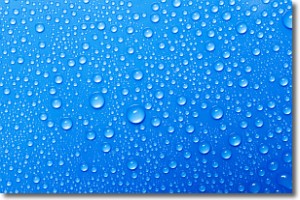
Condensation is the process which creates clouds, and therefore
it is a crucial process in the water cycle.
Condensation is the change of matter from a state of gas into a state of liquid,
and it happens because water molecules release heat into the atmosphere and
become organized into a more closely packed structure, what we might see as
water droplets.
Water is always present in the air around us as a vapor, but it's too small for
us to see. When water undergoes the process of condensation it becomes organized
into visible water droplets. You've probably seen condensation happen before on the
surface of a cold drink!
Next Topic: Contrails
Weather Topic: What are Cumulonimbus Clouds?
Home - Education - Cloud Types - Cumulonimbus Clouds
 Next Topic: Cumulus Clouds
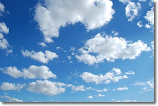
The final form taken by a growing cumulus cloud is the
cumulonimbus cloud, which is very tall and dense.
The tower of a cumulonimbus cloud can soar 23 km into the atmosphere, although
most commonly they stop growing at an altitude of 6 km.
Even small cumulonimbus clouds appear very large in comparison to other cloud types.
They can signal the approach of stormy weather, such as thunderstorms or blizzards.
Next Topic: Cumulus Clouds
Current conditions powered by WeatherAPI.com


