Weather Alert in Pennsylvania
Winter Weather Advisory issued February 5 at 12:41PM EST until February 7 at 7:00AM EST by NWS State College PA
AREAS AFFECTED: Cambria; Somerset
DESCRIPTION: * WHAT...Snow expected. Total snow accumulations between 2 and 4 inches. Localized amounts up to 8 inches in the highest elevations. Winds gusting as high as 45 to 50 mph. * WHERE...Cambria and Somerset Counties. * WHEN...From 10 AM Friday to 7 AM EST Saturday. The heaviest snow is expected Friday afternoon through Friday night. * IMPACTS...Plan on slippery road conditions. The hazardous travel conditions could impact the Friday evening commute. Gusty winds could bring down tree branches and cause significant blowing and drifting snow. * ADDITIONAL DETAILS...Near-blizzard conditions with very low visibility are possible at times late Friday night into early Saturday morning and could make travel extremely difficult. The heaviest snowfall is expected along and to the west of Route 219.
INSTRUCTION: Persons should delay travel if possible. If travel is absolutely necessary, drive with extreme caution and be prepared for sudden changes in visibility. Make sure your vehicle is winterized and in good working order.
Want more detail? Get the Complete 7 Day and Night Detailed Forecast!
Current U.S. National Radar--Current
The Current National Weather Radar is shown below with a UTC Time (subtract 5 hours from UTC to get Eastern Time).

National Weather Forecast--Current
The Current National Weather Forecast and National Weather Map are shown below.

National Weather Forecast for Tomorrow
Tomorrow National Weather Forecast and Tomorrow National Weather Map are show below.

North America Water Vapor (Moisture)
This map shows recent moisture content over North America. Bright and colored areas show high moisture (ie, clouds); brown indicates very little moisture present; black indicates no moisture.

Weather Topic: What are Altostratus Clouds?
Home - Education - Cloud Types - Altostratus Clouds
 Next Topic: Cirrocumulus Clouds
Altostratus clouds form at mid to high-level altitudes
(between 2 and 7 km) and are created by a warm, stable air mass which causes
water vapor
to condense as it rise through the atmosphere. Usually altostratus clouds are
featureless sheets characterized by a uniform color.
In some cases, wind punching through the cloud formation may give it a waved
appearance, called altostratus undulatus. Altostratus clouds
are commonly seen with other cloud formations accompanying them.
Next Topic: Cirrocumulus Clouds
Weather Topic: What are Cirrostratus Clouds?
Home - Education - Cloud Types - Cirrostratus Clouds
 Next Topic: Cirrus Clouds
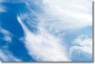
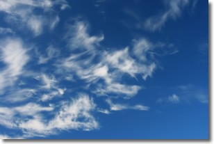
Cirrostratus clouds are high, thin clouds that form above
20,000 feet and are made mostly of ice crystals. They sometimes look like giant
feathers, horse tails, or curls of hair in the sky.
These clouds are pushed by the jet stream and can move at high speeds reaching
100 mph.
What do they indicate?
They indicate that a precipitation is likely within 24 hours.
Next Topic: Cirrus Clouds
Current conditions powered by WeatherAPI.com


