Weather Alert in Connecticut
Special Weather Statement issued March 4 at 3:17AM EST by NWS Albany NY
AREAS AFFECTED: Northern Litchfield; Southern Litchfield; Northern Berkshire; Southern Berkshire; Southern Herkimer; Southern Fulton; Montgomery; Northern Saratoga; Schoharie; Western Schenectady; Eastern Schenectady; Southern Saratoga; Western Albany; Eastern Albany; Western Rensselaer; Eastern Rensselaer; Western Greene; Eastern Greene; Western Columbia; Eastern Columbia; Western Ulster; Eastern Ulster; Western Dutchess; Eastern Dutchess; Northern Fulton; Southeast Warren; Southern Washington; Bennington; Western Windham; Eastern Windham
DESCRIPTION: The wintry mix has diminished across portions of eastern New York and western New England this morning. Some pockets of freezing drizzle may linger from the Hudson River Valley eastward into western New England prior to 6 am. Also, patchy to areas of fog will continue reducing visibilities. Untreated roads and sidewalks will continue to be slick. Some areas of black ice are possible where wet ground has frozen. Use caution out on the roads early this morning, as temperatures continue to be in the 20s to lower 30s.
INSTRUCTION: N/A
Want more detail? Get the Complete 7 Day and Night Detailed Forecast!
Current U.S. National Radar--Current
The Current National Weather Radar is shown below with a UTC Time (subtract 5 hours from UTC to get Eastern Time).

National Weather Forecast--Current
The Current National Weather Forecast and National Weather Map are shown below.

National Weather Forecast for Tomorrow
Tomorrow National Weather Forecast and Tomorrow National Weather Map are show below.

North America Water Vapor (Moisture)
This map shows recent moisture content over North America. Bright and colored areas show high moisture (ie, clouds); brown indicates very little moisture present; black indicates no moisture.

Weather Topic: What is Sleet?
Home - Education - Precipitation - Sleet
 Next Topic: Snow
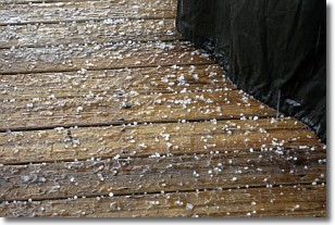
Sleet is a form of precipitation in which small ice pellets are the primary
components. These ice pellets are smaller and more translucent than hailstones,
and harder than graupel. Sleet is caused by specific atmospheric conditions and
therefore typically doesn't last for extended periods of time.
The condition which leads to sleet formation requires a warmer body of air to be
wedged in between two sub-freezing bodies of air. When snow falls through a warmer
layer of air it melts, and as it falls through the next sub-freezing body of air
it freezes again, forming ice pellets known as sleet. In some cases, water
droplets don't have time to freeze before reaching the surface and the result is
freezing rain.
Next Topic: Snow
Weather Topic: What are Stratocumulus Clouds?
Home - Education - Cloud Types - Stratocumulus Clouds
 Next Topic: Stratus Clouds
Stratocumulus clouds are similar to altocumulus clouds in their
fluffy appearance, but have a slightly darker shade due to their additional mass.
A good way to distinguish the two cloud types is to hold your hand out and measure
the size of an individual cloud; if it is the size of your thumb it is generally
an altocumulus cloud, if it is the size of your hand it is generally a
stratocumulus cloud.
It is uncommon for stratocumulus clouds to produce precipitation, but if they do
it is usually a light rain or snow.
Next Topic: Stratus Clouds
Current conditions powered by WeatherAPI.com


