Weather Alert in Virginia
High Wind Watch issued February 5 at 1:07PM EST until February 7 at 7:00PM EST by NWS Baltimore MD/Washington DC
AREAS AFFECTED: Northern Virginia Blue Ridge; Central Virginia Blue Ridge
DESCRIPTION: * WHAT...For the High Wind Watch, northwest winds 25 to 35 mph with gusts up to 65 mph possible. For the Extreme Cold Warning, dangerously cold wind chills as low as 20 to 30 degrees below zero expected. * WHERE...Central Virginia Blue Ridge and Northern Virginia Blue Ridge. * WHEN...For the High Wind Watch, from late Friday night through Saturday evening. For the Extreme Cold Warning, from 4 AM Saturday to 10 AM EST Sunday. * IMPACTS...Damaging winds could blow down trees and power lines. Widespread power outages are possible. Travel could be difficult, especially for high profile vehicles. The cold wind chills as low as 15 below zero could result in hypothermia or frostbite if precautions are not taken. Frostbite and hypothermia will occur if unprotected skin is exposed to these temperatures.
INSTRUCTION: Monitor the latest forecasts and warnings for updates. Dress in layers including a hat, face mask, and gloves if you must go outside. Keep pets indoors as much as possible. Make sure outdoor animals have a warm, dry shelter, food, and unfrozen water. Make frequent checks on older family, friends, and neighbors. Ensure portable heaters are used correctly. Do not use generators or grills inside.
Want more detail? Get the Complete 7 Day and Night Detailed Forecast!
Current U.S. National Radar--Current
The Current National Weather Radar is shown below with a UTC Time (subtract 5 hours from UTC to get Eastern Time).

National Weather Forecast--Current
The Current National Weather Forecast and National Weather Map are shown below.

National Weather Forecast for Tomorrow
Tomorrow National Weather Forecast and Tomorrow National Weather Map are show below.

North America Water Vapor (Moisture)
This map shows recent moisture content over North America. Bright and colored areas show high moisture (ie, clouds); brown indicates very little moisture present; black indicates no moisture.

Weather Topic: What are Fractus Clouds?
Home - Education - Cloud Types - Fractus Clouds
 Next Topic: Freezing Rain
A fractus cloud (scud) is a fragmented, tattered cloud which has
likely been sheared off of another cloud. They are accessory clouds, meaning they
develop from parent clouds, and are named in a way which describes the original
cloud which contained them.
Fractus clouds which have originated from cumulus clouds are referred to as
cumulus fractus, while fractus clouds which have originated from stratus clouds
are referred to as stratus fractus. Under certain conditions a fractus cloud might
merge with another cloud, or develop into a cumulus cloud, but usually a
fractus cloud seen by itself will dissipate rapidly.
They are often observed on the leading and trailing edges of storm clouds,
and are a display of wind activity.
Next Topic: Freezing Rain
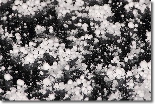
Weather Topic: What is Graupel?
Home - Education - Precipitation - Graupel
 Next Topic: Hail
Graupel is a form of precipitation that is created by atmospheric conditions
which cause supercooled water droplets to contact snow crystals and freeze to
their surface.
Sometimes known as soft hail or snow pellets, graupel is delicate and easily
destroyed by touch. Whereas hail usually falls during severe weather, graupel
doesn't require such conditions to form, and can form in mild precipitation
similar to situations which produce snowfall.
Next Topic: Hail
Current conditions powered by WeatherAPI.com


