Weather Alert in Virginia
High Wind Watch issued February 5 at 1:07PM EST until February 7 at 7:00PM EST by NWS Baltimore MD/Washington DC
AREAS AFFECTED: Northern Virginia Blue Ridge; Central Virginia Blue Ridge
DESCRIPTION: * WHAT...For the High Wind Watch, northwest winds 25 to 35 mph with gusts up to 65 mph possible. For the Extreme Cold Warning, dangerously cold wind chills as low as 20 to 30 degrees below zero expected. * WHERE...Central Virginia Blue Ridge and Northern Virginia Blue Ridge. * WHEN...For the High Wind Watch, from late Friday night through Saturday evening. For the Extreme Cold Warning, from 4 AM Saturday to 10 AM EST Sunday. * IMPACTS...Damaging winds could blow down trees and power lines. Widespread power outages are possible. Travel could be difficult, especially for high profile vehicles. The cold wind chills as low as 15 below zero could result in hypothermia or frostbite if precautions are not taken. Frostbite and hypothermia will occur if unprotected skin is exposed to these temperatures.
INSTRUCTION: Monitor the latest forecasts and warnings for updates. Dress in layers including a hat, face mask, and gloves if you must go outside. Keep pets indoors as much as possible. Make sure outdoor animals have a warm, dry shelter, food, and unfrozen water. Make frequent checks on older family, friends, and neighbors. Ensure portable heaters are used correctly. Do not use generators or grills inside.
Want more detail? Get the Complete 7 Day and Night Detailed Forecast!
Current U.S. National Radar--Current
The Current National Weather Radar is shown below with a UTC Time (subtract 5 hours from UTC to get Eastern Time).

National Weather Forecast--Current
The Current National Weather Forecast and National Weather Map are shown below.

National Weather Forecast for Tomorrow
Tomorrow National Weather Forecast and Tomorrow National Weather Map are show below.

North America Water Vapor (Moisture)
This map shows recent moisture content over North America. Bright and colored areas show high moisture (ie, clouds); brown indicates very little moisture present; black indicates no moisture.

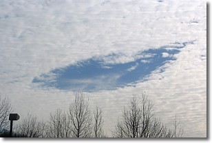
Weather Topic: What are Hole Punch Clouds?
Home - Education - Cloud Types - Hole Punch Clouds
 Next Topic: Mammatus Clouds
A hole punch cloud is an unusual occurrence when a disk-shaped
hole appears in a cirrostratus, cirrocumulus, or altocumulus cloud.
When part of the cloud forms ice crystals, water droplets in the surrounding area
of the cloud evaporate. The effect of this process produces a large elliptical
gap in the cloud. The hole punch cloud formation is rare, but it is not specific
to any geographic area.
Other names which have been used to describe this phenomena include fallstreak hole,
skypunch, and cloud hole.
Next Topic: Mammatus Clouds
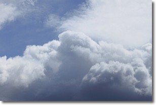
Weather Topic: What are Nimbostratus Clouds?
Home - Education - Cloud Types - Nimbostratus Clouds
 Next Topic: Precipitation
A nimbostratus cloud is similar to a stratus cloud in its formless,
smooth appearance. However, a nimbostratus cloud is darker than a stratus cloud,
because it is thicker.
Unlike a stratus cloud, a nimbostratus cloud typically brings with it the threat
of moderate to heavy precipitation. In some cases, the precipitation may evaporate
before reaching the ground, a phenomenon known as virga.
Next Topic: Precipitation
Current conditions powered by WeatherAPI.com


