Weather Alert in Maryland
High Wind Watch issued February 5 at 1:07PM EST until February 7 at 7:00PM EST by NWS Baltimore MD/Washington DC
AREAS AFFECTED: Extreme Western Allegany; Western Garrett; Eastern Garrett; Western Highland; Western Grant; Western Mineral; Western Pendleton
DESCRIPTION: * WHAT...For the High Wind Watch, northwest winds 20 to 30 mph with gusts up to 60 mph possible. For the Extreme Cold Warning, dangerously cold wind chills as low as 20 to 30 degrees below zero expected. * WHERE...In Maryland, Eastern Garrett, Extreme Western Allegany, and Western Garrett Counties. In Virginia, Western Highland County. In West Virginia, Western Grant, Western Mineral, and Western Pendleton Counties. * WHEN...For the High Wind Watch, from late Friday night through Saturday evening. For the Extreme Cold Warning, from 4 AM Saturday to 10 AM EST Sunday. * IMPACTS...Damaging winds could blow down trees and power lines. Widespread power outages are possible. Travel could be difficult, especially for high profile vehicles. The dangerously cold wind chills as low as 25 below zero could cause frostbite on exposed skin in as little as 30 minutes. Frostbite and hypothermia will occur if unprotected skin is exposed to these temperatures.
INSTRUCTION: Monitor the latest forecasts and warnings for updates. Dress in layers including a hat, face mask, and gloves if you must go outside. Keep pets indoors as much as possible. Make sure outdoor animals have a warm, dry shelter, food, and unfrozen water. Make frequent checks on older family, friends, and neighbors. Ensure portable heaters are used correctly. Do not use generators or grills inside.
Want more detail? Get the Complete 7 Day and Night Detailed Forecast!
Current U.S. National Radar--Current
The Current National Weather Radar is shown below with a UTC Time (subtract 5 hours from UTC to get Eastern Time).

National Weather Forecast--Current
The Current National Weather Forecast and National Weather Map are shown below.

National Weather Forecast for Tomorrow
Tomorrow National Weather Forecast and Tomorrow National Weather Map are show below.

North America Water Vapor (Moisture)
This map shows recent moisture content over North America. Bright and colored areas show high moisture (ie, clouds); brown indicates very little moisture present; black indicates no moisture.

Weather Topic: What is Drizzle?
Home - Education - Precipitation - Drizzle
 Next Topic: Evaporation
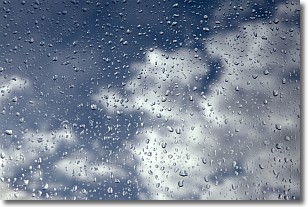
Drizzle is precipitation in the form of water droplets which are
smaller than raindrops.
Drizzle is characterized by fine, gently falling droplets and typically does not
impact human habitation in a negative way. The exception to this is freezing drizzle,
a condition where drizzle freezes immediately upon reaching earth's surface.
Freezing drizzle is still less dangerous than freezing rain, but can
potentially result in hazardous road conditions.
Next Topic: Evaporation
Weather Topic: What is Fog?
Home - Education - Cloud Types - Fog
 Next Topic: Fractus Clouds
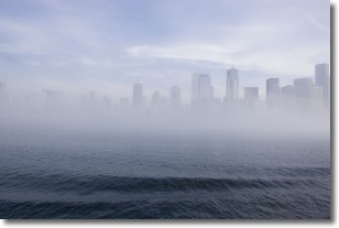
Fog is technically a type of stratus cloud, which lies along the
ground and obscures visibility.
It is usually created when humidity in the air condenses into tiny water droplets.
Because of this, some places are more prone to foggy weather, such as regions
close to a body of water.
Fog is similar to mist; both are the appearance of water droplets suspended in
the air, but fog is the term applied to the condition when visibility is less than 1 km.
Next Topic: Fractus Clouds
Current conditions powered by WeatherAPI.com


