Weather Alert in Pennsylvania
Winter Weather Advisory issued February 5 at 9:57PM EST until February 7 at 1:00AM EST by NWS Cleveland OH
AREAS AFFECTED: Southern Erie
DESCRIPTION: * WHAT...Snow expected. Total snow accumulations between 3 and 5 inches. Winds gusting as high as 40 mph may will produce patchy to areas of blowing snow Friday evening. * WHERE...Southern Erie County. * WHEN...From 7 AM Friday to 1 AM EST Saturday. * IMPACTS...Plan on slippery conditions with with slower travel likely The hazardous conditions could impact the Friday morning and evening commutes. Blowing snow may reduce visibility less than a mile at times. * ADDITIONAL DETAILS...A broken line of snow squalls or heavier burst of snow may develop along an Arctic front as it pushes through the area Friday evening.
INSTRUCTION: Slow down and use caution while traveling. The Pennsylvania Department of Transportation and Pennsylvania Turnpike Commission strongly encourage motorists to heed all travel restrictions and delay unnecessary travel. Visit www.511pa.com for the latest travel, roadway, and traffic conditions.
Want more detail? Get the Complete 7 Day and Night Detailed Forecast!
Current U.S. National Radar--Current
The Current National Weather Radar is shown below with a UTC Time (subtract 5 hours from UTC to get Eastern Time).

National Weather Forecast--Current
The Current National Weather Forecast and National Weather Map are shown below.

National Weather Forecast for Tomorrow
Tomorrow National Weather Forecast and Tomorrow National Weather Map are show below.

North America Water Vapor (Moisture)
This map shows recent moisture content over North America. Bright and colored areas show high moisture (ie, clouds); brown indicates very little moisture present; black indicates no moisture.

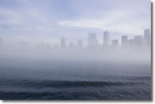
Weather Topic: What is Fog?
Home - Education - Cloud Types - Fog
 Next Topic: Fractus Clouds
Fog is technically a type of stratus cloud, which lies along the
ground and obscures visibility.
It is usually created when humidity in the air condenses into tiny water droplets.
Because of this, some places are more prone to foggy weather, such as regions
close to a body of water.
Fog is similar to mist; both are the appearance of water droplets suspended in
the air, but fog is the term applied to the condition when visibility is less than 1 km.
Next Topic: Fractus Clouds
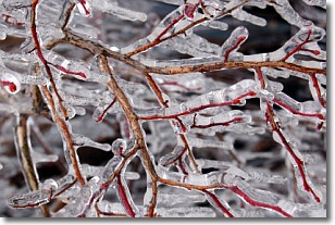
Weather Topic: What is Freezing Rain?
Home - Education - Precipitation - Freezing Rain
 Next Topic: Graupel
Freezing rain is a condition where precipitation which has fallen in the form of
water droplets reaches temperatures which are below freezing and freezes upon
coming into contact
with surface objects. The result of this precipitation is a glaze of ice which
can be damaging to plants and man-made structures. A severe onset of freezing
rain which results in a very thick glaze of ice is known as an ice storm.
Next Topic: Graupel
Current conditions powered by WeatherAPI.com


