Weather Alert in North Carolina
Special Weather Statement issued February 5 at 7:05PM EST by NWS Wilmington NC
AREAS AFFECTED: Robeson; Bladen; Columbus; Inland Pender; Coastal Pender; Inland New Hanover; Coastal New Hanover; Inland Brunswick; Coastal Brunswick; Marlboro; Darlington; Dillon; Florence; Marion; Williamsburg; Coastal Horry; Inland Georgetown; Coastal Georgetown; Central Horry; Northern Horry
DESCRIPTION: Standing water from the recent rainfall and any leftover melting snow will result in patchy black ice along or across area roadways and thoroughfares as temperatures drop to and below 32 later this evening, and into the 20s overnight. Icy spots could form on paved surfaces such as bridges and overpasses, primary and especially less traveled secondary roads, parking lots, sidewalks and driveways. Black ice is difficult to see and distinguish from dry surfaces. The deceptive nature of black ice can catch you unaware while you are driving or walking, causing you to lose control of your motor vehicle or for one to slip and fall.
INSTRUCTION: If you plan to drive or walk, remain alert for those slick spots. Slow your driving speed and use care when walking on sidewalks, driveways or across parking lots. Slips and falls constitute a leading cause of injuries during the winter weather season.
Want more detail? Get the Complete 7 Day and Night Detailed Forecast!
Current U.S. National Radar--Current
The Current National Weather Radar is shown below with a UTC Time (subtract 5 hours from UTC to get Eastern Time).

National Weather Forecast--Current
The Current National Weather Forecast and National Weather Map are shown below.

National Weather Forecast for Tomorrow
Tomorrow National Weather Forecast and Tomorrow National Weather Map are show below.

North America Water Vapor (Moisture)
This map shows recent moisture content over North America. Bright and colored areas show high moisture (ie, clouds); brown indicates very little moisture present; black indicates no moisture.

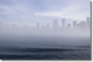
Weather Topic: What is Fog?
Home - Education - Cloud Types - Fog
 Next Topic: Fractus Clouds
Fog is technically a type of stratus cloud, which lies along the
ground and obscures visibility.
It is usually created when humidity in the air condenses into tiny water droplets.
Because of this, some places are more prone to foggy weather, such as regions
close to a body of water.
Fog is similar to mist; both are the appearance of water droplets suspended in
the air, but fog is the term applied to the condition when visibility is less than 1 km.
Next Topic: Fractus Clouds
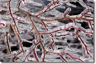
Weather Topic: What is Freezing Rain?
Home - Education - Precipitation - Freezing Rain
 Next Topic: Graupel
Freezing rain is a condition where precipitation which has fallen in the form of
water droplets reaches temperatures which are below freezing and freezes upon
coming into contact
with surface objects. The result of this precipitation is a glaze of ice which
can be damaging to plants and man-made structures. A severe onset of freezing
rain which results in a very thick glaze of ice is known as an ice storm.
Next Topic: Graupel
Current conditions powered by WeatherAPI.com


