Weather Alert in Indiana
Flood Warning issued March 4 at 3:57AM EST by NWS Indianapolis IN
AREAS AFFECTED: Johnson, IN
DESCRIPTION: ...The Flood Warning continues for the following rivers in Indiana... Haw Creek near Clifford. White River at Elliston. Youngs Creek at Amity. ...The Flood Warning is extended for the following rivers in Indiana... White River at Newberry. .Between 2 and 4 inches of rain have fallen across central Indiana as of early Wednesday morning. Up to 2 inches have fallen in south-central Indiana. This has led creeks to rise above flood stage and rivers will follow in the coming days. Additional rain is in the forecast over the next several days. * WHAT...Minor flooding is occurring and minor flooding is forecast. * WHERE...Youngs Creek at Amity. * WHEN...Until further notice. * IMPACTS...At 10.0 feet, Significant flooding in progress. Parks and some local roads are flooded by a foot or more of water. Agricultural flooding is noticeable. * ADDITIONAL DETAILS... - At 3:15 AM EST Wednesday the stage was 9.2 feet. - Recent Activity...The maximum river stage in the 24 hours ending at 3:15 AM EST Wednesday was 9.2 feet. - Forecast...The river is expected to rise to 9.9 feet this afternoon. Additional rises are possible thereafter. - Flood stage is 7.0 feet. - http://www.weather.gov/safety/flood
INSTRUCTION: Stay tuned to further developments by listening to your local radio, television, or NOAA Weather Radio for further information. Be especially cautious at night when it is harder to recognize the dangers of flooding. Additional information is available at www.weather.gov/ind. The next statement should be issued this afternoon by around 330 PM EST.
Want more detail? Get the Complete 7 Day and Night Detailed Forecast!
Current U.S. National Radar--Current
The Current National Weather Radar is shown below with a UTC Time (subtract 5 hours from UTC to get Eastern Time).

National Weather Forecast--Current
The Current National Weather Forecast and National Weather Map are shown below.

National Weather Forecast for Tomorrow
Tomorrow National Weather Forecast and Tomorrow National Weather Map are show below.

North America Water Vapor (Moisture)
This map shows recent moisture content over North America. Bright and colored areas show high moisture (ie, clouds); brown indicates very little moisture present; black indicates no moisture.

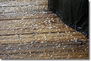
Weather Topic: What is Sleet?
Home - Education - Precipitation - Sleet
 Next Topic: Snow
Sleet is a form of precipitation in which small ice pellets are the primary
components. These ice pellets are smaller and more translucent than hailstones,
and harder than graupel. Sleet is caused by specific atmospheric conditions and
therefore typically doesn't last for extended periods of time.
The condition which leads to sleet formation requires a warmer body of air to be
wedged in between two sub-freezing bodies of air. When snow falls through a warmer
layer of air it melts, and as it falls through the next sub-freezing body of air
it freezes again, forming ice pellets known as sleet. In some cases, water
droplets don't have time to freeze before reaching the surface and the result is
freezing rain.
Next Topic: Snow
Weather Topic: What are Stratocumulus Clouds?
Home - Education - Cloud Types - Stratocumulus Clouds
 Next Topic: Stratus Clouds
Stratocumulus clouds are similar to altocumulus clouds in their
fluffy appearance, but have a slightly darker shade due to their additional mass.
A good way to distinguish the two cloud types is to hold your hand out and measure
the size of an individual cloud; if it is the size of your thumb it is generally
an altocumulus cloud, if it is the size of your hand it is generally a
stratocumulus cloud.
It is uncommon for stratocumulus clouds to produce precipitation, but if they do
it is usually a light rain or snow.
Next Topic: Stratus Clouds
Current conditions powered by WeatherAPI.com


