Weather Alert in Alaska
Winter Weather Advisory issued March 3 at 10:42PM AKST until March 4 at 12:00PM AKST by NWS Juneau AK
AREAS AFFECTED: City and Borough of Yakutat
DESCRIPTION: ...SNOW FOR THE NORTHERN AND CENTRAL PANHANDLE THROUGH WEDNESDAY... The next surge of snow is expected this overnight as the main low moves closer to the panhandle bringing more moisture to the area. This next surge of moisture is expected to bring increasing snowfall rates to the Icy Strait corridor this evening. Along with this second wave of snow, the original band of snow is expected to set up around the Yakutat area bringing more accumulating snow to the area with the heaviest parts to the west of Yakutat. * WHAT...Snow. Additional snow accumulations of 4 to 6 inches. * WHERE...City and Borough of Yakutat. * WHEN...Until noon AKST Wednesday. * IMPACTS...Travel could be very difficult. * ADDITIONAL DETAILS...Snowfall amounts could be higher if the heaviest snow band, which is currently projected to set up west of Yakutat, moves further east.
INSTRUCTION: Slow down and use caution while traveling. People are urged to prepare their property before the onset of winter weather. For the latest road conditions, where available, call 5 1 1 or visit 511.alaska.gov.
Want more detail? Get the Complete 7 Day and Night Detailed Forecast!
Current U.S. National Radar--Current
The Current National Weather Radar is shown below with a UTC Time (subtract 5 hours from UTC to get Eastern Time).

National Weather Forecast--Current
The Current National Weather Forecast and National Weather Map are shown below.

National Weather Forecast for Tomorrow
Tomorrow National Weather Forecast and Tomorrow National Weather Map are show below.

North America Water Vapor (Moisture)
This map shows recent moisture content over North America. Bright and colored areas show high moisture (ie, clouds); brown indicates very little moisture present; black indicates no moisture.

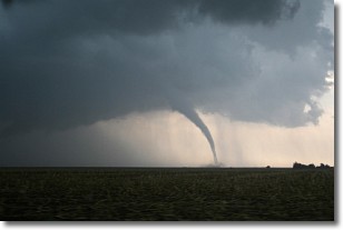
Weather Topic: What are Wall Clouds?
Home - Education - Cloud Types - Wall Clouds
 Next Topic: Altocumulus Clouds
A wall cloud forms underneath the base of a cumulonimbus cloud,
and can be a hotbed for deadly tornadoes.
Wall clouds are formed by air flowing into the cumulonimbus clouds, which can
result in the wall cloud descending from the base of the cumulonimbus cloud, or
rising fractus clouds which join to the base of the storm cloud as the wall cloud
takes shape.
Wall clouds can be very large, and in the Northern Hemisphere they generally
form at the southern edge of cumulonimbus clouds.
Next Topic: Altocumulus Clouds
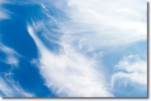
Weather Topic: What are Altostratus Clouds?
Home - Education - Cloud Types - Altostratus Clouds
 Next Topic: Cirrocumulus Clouds
Altostratus clouds form at mid to high-level altitudes
(between 2 and 7 km) and are created by a warm, stable air mass which causes
water vapor
to condense as it rise through the atmosphere. Usually altostratus clouds are
featureless sheets characterized by a uniform color.
In some cases, wind punching through the cloud formation may give it a waved
appearance, called altostratus undulatus. Altostratus clouds
are commonly seen with other cloud formations accompanying them.
Next Topic: Cirrocumulus Clouds
Current conditions powered by WeatherAPI.com


