Weather Alert in Maryland
Winter Storm Warning issued February 5 at 1:17PM EST until February 7 at 7:00AM EST by NWS Baltimore MD/Washington DC
AREAS AFFECTED: Western Garrett; Eastern Garrett; Western Grant; Western Pendleton
DESCRIPTION: ...NEAR BLIZZARD CONDITIONS EXPECTED LATE FRIDAY NIGHT INTO EARLY SATURDAY... .A strong Arctic front will deliver heavy upslope snow showers and squalls, strong winds, and dangerously cold wind chills to the Alleghenies late Friday into the Saturday. * WHAT...Heavy snow expected. Total snow accumulations of 6 to 8 inches, with locally higher totals along western favored ridges (such as Backbone Mountain, Piney Mountain, and Keysers Ridge). Winds gusting as high as 50 to 60 mph that lead to significant blowing and drifting snow. * WHERE...In Maryland, Eastern Garrett and Western Garrett Counties. In West Virginia, Western Grant and Western Pendleton Counties. * WHEN...From 10 AM Friday to 7 AM EST Saturday. * IMPACTS...Roads, and especially bridges and overpasses, will likely become slick and hazardous. Visibilities may drop below 1/4 mile due to falling and blowing snow. Travel could be very difficult. The hazardous conditions could impact the Friday evening commute. Strong winds could cause tree damage. Travel could be treacherous and potentially life-threatening on I-68/US-40 west of Frostburg, MD, US-219 from the PA/MD Line south to WV Line, US-48 west of Moorefield, WV, and US-33/WV-28 west of Franklin, WV. * ADDITIONAL DETAILS...Expect roads to become impassable especially those in open areas due to blowing and drifting snow Friday night through Saturday. Wind chills will fall below zero Friday night with values as low as 20 to 30 degrees below zero from Saturday morning through Sunday morning. Frostbite and hypothermia can occur in these conditions in less than 30 minutes.
INSTRUCTION: Persons are urged to stay indoors until conditions improve. If you must go outside, dress in layers. Several layers of clothes will keep you warmer than a single heavy coat. Cover exposed skin to reduce your risk of frostbite or hypothermia. Gloves, a scarf, and a hat will keep you from losing your body heat. Persons should delay all travel if possible. If travel is absolutely necessary, drive with extreme caution and be prepared for sudden changes in visibility. Make sure your car is winterized and in good working order.
Want more detail? Get the Complete 7 Day and Night Detailed Forecast!
Current U.S. National Radar--Current
The Current National Weather Radar is shown below with a UTC Time (subtract 5 hours from UTC to get Eastern Time).

National Weather Forecast--Current
The Current National Weather Forecast and National Weather Map are shown below.

National Weather Forecast for Tomorrow
Tomorrow National Weather Forecast and Tomorrow National Weather Map are show below.

North America Water Vapor (Moisture)
This map shows recent moisture content over North America. Bright and colored areas show high moisture (ie, clouds); brown indicates very little moisture present; black indicates no moisture.

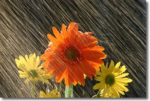
Weather Topic: What is Precipitation?
Home - Education - Precipitation - Precipitation
 Next Topic: Rain
Precipitation can refer to many different forms of water that
may fall from clouds. Precipitation occurs after a cloud has become saturated to
the point where its water particles are more dense than the air below the cloud.
In most cases, precipitation will reach the ground, but it is not uncommon for
precipitation to evaporate before it reaches the earth's surface.
When precipitation evaporates before it contacts the ground it is called Virga.
Graupel, hail, sleet, rain, drizzle, and snow are forms of precipitation, but fog
and mist are not considered precipitation because the water vapor which
constitutes them isn't dense enough to fall to the ground.
Next Topic: Rain
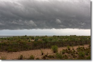
Weather Topic: What are Shelf Clouds?
Home - Education - Cloud Types - Shelf Clouds
 Next Topic: Sleet
A shelf cloud is similar to a wall cloud, but forms at the front
of a storm cloud, instead of at the rear, where wall clouds form.
A shelf cloud is caused by a series of events set into motion by the advancing
storm; first, cool air settles along the ground where precipitation has just fallen.
As the cool air is brought in, the warmer air is displaced, and rises above it,
because it is less dense. When the warmer air reaches the bottom of the storm cloud,
it begins to cool again, and the resulting condensation is a visible shelf cloud.
Next Topic: Sleet
Current conditions powered by WeatherAPI.com


