Weather Alert in Oregon
Beach Hazards Statement issued February 5 at 2:08PM PST until February 6 at 10:00PM PST by NWS Medford OR
AREAS AFFECTED: South Central Oregon Coast; Curry County Coast
DESCRIPTION: * WHAT...Moderate risk of sneaker waves expected. * WHERE...Beaches of Curry, Coos, and Douglas counties. * WHEN...From 7 PM PST this evening through Friday evening. * IMPACTS...Sneaker waves can run up significantly farther on beaches than normal, including over rocks and jetties. These waves can suddenly knock people off of their feet and sweep them into the ocean. The waves can also move logs or other objects which could crush or trap anyone caught underneath. * ADDITIONAL DETAILS...While sneaker waves can occur at any time, the greatest risk is on an incoming tide. Please be aware of the tides if venturing out onto the beaches. The high tides will occur roughly between 2 and 3 AM and again around 2 to 3 PM PST Friday. * View the hazard area in detail at https://www.wrh.noaa.gov/map/?wfo=mfr
INSTRUCTION: Avoid climbing on rocks and jetties. Stay away from the ocean and remain out of the water to avoid hazardous conditions.
Want more detail? Get the Complete 7 Day and Night Detailed Forecast!
Current U.S. National Radar--Current
The Current National Weather Radar is shown below with a UTC Time (subtract 5 hours from UTC to get Eastern Time).

National Weather Forecast--Current
The Current National Weather Forecast and National Weather Map are shown below.

National Weather Forecast for Tomorrow
Tomorrow National Weather Forecast and Tomorrow National Weather Map are show below.

North America Water Vapor (Moisture)
This map shows recent moisture content over North America. Bright and colored areas show high moisture (ie, clouds); brown indicates very little moisture present; black indicates no moisture.

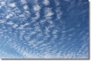
Weather Topic: What are Cirrocumulus Clouds?
Home - Education - Cloud Types - Cirrocumulus Clouds
 Next Topic: Cirrostratus Clouds
Cirrocumulus clouds form at high altitudes (usually around 5 km)
and have distinguishing characteristics displayed in a fine layer of
small cloud patches. These small cloud patches are sometimes referred to as
"cloudlets" in relation to the whole cloud formation.
Cirrocumulus clouds are formed from ice crystals and water droplets. Often, the
water droplets in the cloud freeze into ice crystals and the cloud becomes a
cirrostratus cloud. Because of this common occurrence, cirrocumulus cloud
formations generally pass rapidly.
Next Topic: Cirrostratus Clouds
Weather Topic: What are Cirrus Clouds?
Home - Education - Cloud Types - Cirrus Clouds
 Next Topic: Condensation
Cirrus clouds are high-level clouds that occur above 20,000 feet
and are composed mainly of ice crystals.
They are thin and wispy in appearance.
What do they indicate?
They are often the first sign of an approaching storm.
Next Topic: Condensation
Current conditions powered by WeatherAPI.com


