Weather Alert in Arkansas
Air Quality Alert issued September 11 at 3:16PM CDT by NWS Memphis TN
AREAS AFFECTED: Crittenden; DeSoto; Shelby
DESCRIPTION: AQAMEG The Shelby County Health Department has issued a Code Orange Ozone Forecast effective for Shelby County Tennessee, Crittenden County Arkansas, and DeSoto County Mississippi, including the city of Memphis for Friday. This ozone forecast is due to forecasted ozone values that will be unhealthy for sensitive groups. These values will exceed the Environmental Protection Agency's federal safe health standard. The Shelby County Health Department recommends that sensitive groups which include active children and adults, and people with respiratory disease, such as asthma, limit prolonged outdoor exertion. Please continue to check the latest air quality forecasts and updates until monitored values return to safe levels. For more information go to www.airnow.gov.
INSTRUCTION: N/A
Want more detail? Get the Complete 7 Day and Night Detailed Forecast!
Current U.S. National Radar--Current
The Current National Weather Radar is shown below with a UTC Time (subtract 5 hours from UTC to get Eastern Time).

National Weather Forecast--Current
The Current National Weather Forecast and National Weather Map are shown below.

National Weather Forecast for Tomorrow
Tomorrow National Weather Forecast and Tomorrow National Weather Map are show below.

North America Water Vapor (Moisture)
This map shows recent moisture content over North America. Bright and colored areas show high moisture (ie, clouds); brown indicates very little moisture present; black indicates no moisture.

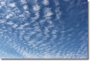
Weather Topic: What are Cirrocumulus Clouds?
Home - Education - Cloud Types - Cirrocumulus Clouds
 Next Topic: Cirrostratus Clouds
Cirrocumulus clouds form at high altitudes (usually around 5 km)
and have distinguishing characteristics displayed in a fine layer of
small cloud patches. These small cloud patches are sometimes referred to as
"cloudlets" in relation to the whole cloud formation.
Cirrocumulus clouds are formed from ice crystals and water droplets. Often, the
water droplets in the cloud freeze into ice crystals and the cloud becomes a
cirrostratus cloud. Because of this common occurrence, cirrocumulus cloud
formations generally pass rapidly.
Next Topic: Cirrostratus Clouds
Weather Topic: What are Cirrus Clouds?
Home - Education - Cloud Types - Cirrus Clouds
 Next Topic: Condensation
Cirrus clouds are high-level clouds that occur above 20,000 feet
and are composed mainly of ice crystals.
They are thin and wispy in appearance.
What do they indicate?
They are often the first sign of an approaching storm.
Next Topic: Condensation
Current conditions powered by WeatherAPI.com


