Weather Alert in Georgia
Flood Watch issued August 2 at 3:12PM EDT until August 3 at 4:00AM EDT by NWS Tallahassee FL
AREAS AFFECTED: Quitman; Clay; Randolph; Calhoun; Terrell; Dougherty; Lee; Worth; Turner; Tift; Ben Hill; Irwin; Early; Miller; Baker; Mitchell; Colquitt; Cook; Berrien; Decatur; Grady; Thomas; Brooks; Lowndes; Lanier
DESCRIPTION: * WHAT...Flash flooding caused by excessive rainfall is possible across Southwest and South Central Georgia. * WHERE...For the following counties in South Central Georgia, Ben Hill, Berrien, Brooks, Colquitt, Cook, Irwin, Lanier, Lowndes, Thomas, Tift, Turner and Worth. In southwest Georgia, Baker, Calhoun, Clay, Decatur, Dougherty, Early, Grady, Lee, Miller, Mitchell, Quitman, Randolph and Terrell. * WHEN...Through 4 AM EDT Sunday Morning. * IMPACTS...Excessive runoff may result in flash flooding of roadways as well as greater impacts in urban areas where flood-prone neighborhoods could be especially vulnerable to rising water. Small creeks may also rise rapidly, leading to flooding. * ADDITIONAL DETAILS... - A very moist airmass is in place across the region and numerous showers and thunderstorms are expected to develop later this afternoon and evening across South Georgia. Due to the slow motion of these storms, some areas could see rainfall totals of 3 to 5 inches with isolated maximum amounts of 7 inches through tonight. - http://www.weather.gov/safety/flood
INSTRUCTION: You should monitor later forecasts and be alert for possible Flash Flood Warnings. Those living in areas prone to flooding should be prepared to take action should flash flooding develop.
Want more detail? Get the Complete 7 Day and Night Detailed Forecast!
Current U.S. National Radar--Current
The Current National Weather Radar is shown below with a UTC Time (subtract 5 hours from UTC to get Eastern Time).

National Weather Forecast--Current
The Current National Weather Forecast and National Weather Map are shown below.

National Weather Forecast for Tomorrow
Tomorrow National Weather Forecast and Tomorrow National Weather Map are show below.

North America Water Vapor (Moisture)
This map shows recent moisture content over North America. Bright and colored areas show high moisture (ie, clouds); brown indicates very little moisture present; black indicates no moisture.

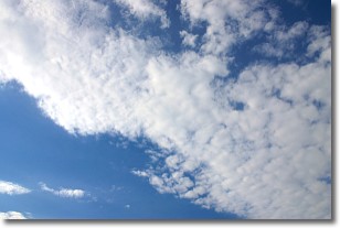
Weather Topic: What are Altocumulus Clouds?
Home - Education - Cloud Types - Altocumulus Clouds
 Next Topic: Altostratus Clouds
Similar to cirrocumulus clouds, altocumulus clouds are
characterized by cloud patches. They are distinguished by larger cloudlets
than cirrocumulus clouds but are still smaller than stratocumulus clouds.
Altocumulus clouds most commonly form in middle altitudes (between 2 and 5 km)
and may resemble, at times, the shape of a flying saucer.
These uncommon formations, called altocumulus lenticularis, are created by uplift
in the atmosphere and are most often seen in close proximity to mountains.
Next Topic: Altostratus Clouds
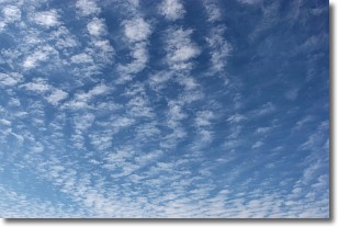
Weather Topic: What are Cirrocumulus Clouds?
Home - Education - Cloud Types - Cirrocumulus Clouds
 Next Topic: Cirrostratus Clouds
Cirrocumulus clouds form at high altitudes (usually around 5 km)
and have distinguishing characteristics displayed in a fine layer of
small cloud patches. These small cloud patches are sometimes referred to as
"cloudlets" in relation to the whole cloud formation.
Cirrocumulus clouds are formed from ice crystals and water droplets. Often, the
water droplets in the cloud freeze into ice crystals and the cloud becomes a
cirrostratus cloud. Because of this common occurrence, cirrocumulus cloud
formations generally pass rapidly.
Next Topic: Cirrostratus Clouds
Current conditions powered by WeatherAPI.com


