Weather Alert in Ohio
Special Weather Statement issued April 29 at 8:22PM EDT by NWS Wilmington OH
AREAS AFFECTED: Ross; Highland; Adams; Pike; Scioto
DESCRIPTION: At 822 PM EDT, a strong thunderstorm was located near Bainbridge, moving east at 45 mph. HAZARD...Wind gusts up to 40 mph, pea size hail, frequent cloud-to-ground lightning, and very heavy rain. SOURCE...Radar indicated. IMPACT...Gusty winds could knock down tree limbs and blow around unsecured objects. Hail may cause minor damage to vegetation. Lightning can cause serious injury or death. Visibility will be poor and hydroplaning is possible. Locations impacted include... Wakefield, Pike County Airport, Pike Lake, Mooresville, May Hill, Kincaid Springs, Omega, Locust Grove, Givens, Knockemstiff, Belfast, Seaman, Bainbridge, Mount Joy, Bear Creek, Highland Holiday, Massieville, Beaver, Lake White, and Rocky Fork Lake.
INSTRUCTION: If outdoors, consider seeking shelter inside a sturdy building. Motorists should slow down and use extra caution. When thunder roars, go indoors! Do not stay in the open or seek shelter under trees when lightning threatens. Residents in these areas should remain alert. If this storm becomes stronger, then a warning may be needed. To report hazardous weather conditions, go to our website at weather.gov/iln and submit your report via social media, when you can do so safely.
Want more detail? Get the Complete 7 Day and Night Detailed Forecast!
Current U.S. National Radar--Current
The Current National Weather Radar is shown below with a UTC Time (subtract 5 hours from UTC to get Eastern Time).

National Weather Forecast--Current
The Current National Weather Forecast and National Weather Map are shown below.

National Weather Forecast for Tomorrow
Tomorrow National Weather Forecast and Tomorrow National Weather Map are show below.

North America Water Vapor (Moisture)
This map shows recent moisture content over North America. Bright and colored areas show high moisture (ie, clouds); brown indicates very little moisture present; black indicates no moisture.

Weather Topic: What are Hole Punch Clouds?
Home - Education - Cloud Types - Hole Punch Clouds
 Next Topic: Mammatus Clouds
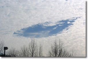
A hole punch cloud is an unusual occurrence when a disk-shaped
hole appears in a cirrostratus, cirrocumulus, or altocumulus cloud.
When part of the cloud forms ice crystals, water droplets in the surrounding area
of the cloud evaporate. The effect of this process produces a large elliptical
gap in the cloud. The hole punch cloud formation is rare, but it is not specific
to any geographic area.
Other names which have been used to describe this phenomena include fallstreak hole,
skypunch, and cloud hole.
Next Topic: Mammatus Clouds
Weather Topic: What are Nimbostratus Clouds?
Home - Education - Cloud Types - Nimbostratus Clouds
 Next Topic: Precipitation
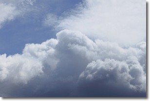
A nimbostratus cloud is similar to a stratus cloud in its formless,
smooth appearance. However, a nimbostratus cloud is darker than a stratus cloud,
because it is thicker.
Unlike a stratus cloud, a nimbostratus cloud typically brings with it the threat
of moderate to heavy precipitation. In some cases, the precipitation may evaporate
before reaching the ground, a phenomenon known as virga.
Next Topic: Precipitation
Current conditions powered by WeatherAPI.com


