Weather Alert in Louisiana
Air Quality Alert issued September 11 at 3:26PM CDT by NWS New Orleans LA
AREAS AFFECTED: St. John The Baptist; St. Charles; Upper St. Bernard; Coastal Jefferson; Lower Plaquemines; Lower St. Bernard; Southeast St. Tammany; Western Orleans; Eastern Orleans; Northern St. Tammany; Southwestern St. Tammany; Upper Jefferson; Lower Jefferson; Upper Plaquemines; Central Plaquemines
DESCRIPTION: The Louisiana Department of Environmental Quality is forecasting an Ozone Advisory Day for Orleans, Jefferson, St John the Baptist, St Charles, St Bernard, St Tammany, and Plaquemines Parishes, . The Air Quality Index indicates that ozone will be at the Orange level, which is unhealthy for sensitive groups. Increasing ozone levels may cause unhealthy air quality during afternoon hours. Active children and adults, the elderly, and people with respiratory diseases such as asthma should avoid prolonged outdoor exertion. Please take whatever voluntary steps you can to reduce emissions that contribute to ozone formation. Drive less and make sure your automobile is in good working condition. Make sure your gas cap is tight. Wait until after 6 PM to refuel your vehicle and use gas powered lawn equipment. More information about current air quality and what you can do to help prevent ozone formation is available at the D E Q website www.deq.louisiana.gov/enviroflash or by calling 8 6 6 8 9 6 5 3 3 7.
INSTRUCTION: N/A
Want more detail? Get the Complete 7 Day and Night Detailed Forecast!
Current U.S. National Radar--Current
The Current National Weather Radar is shown below with a UTC Time (subtract 5 hours from UTC to get Eastern Time).

National Weather Forecast--Current
The Current National Weather Forecast and National Weather Map are shown below.

National Weather Forecast for Tomorrow
Tomorrow National Weather Forecast and Tomorrow National Weather Map are show below.

North America Water Vapor (Moisture)
This map shows recent moisture content over North America. Bright and colored areas show high moisture (ie, clouds); brown indicates very little moisture present; black indicates no moisture.

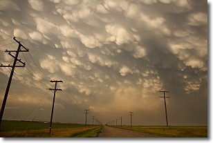
Weather Topic: What are Mammatus Clouds?
Home - Education - Cloud Types - Mammatus Clouds
 Next Topic: Nimbostratus Clouds
A mammatus cloud is a cloud with a unique feature which resembles
a web of pouches hanging along the base of the cloud.
In the United States, mammatus clouds tend to form in the warmer months, commonly
in the Midwest and eastern regions.
While they usually form at the bottom of a cumulonimbis cloud, they can also form
under altostratus, altocumulus, stratocumulus, and cirrus clouds. Mammatus clouds
warn that severe weather is close.
Next Topic: Nimbostratus Clouds
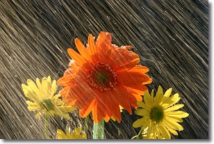
Weather Topic: What is Precipitation?
Home - Education - Precipitation - Precipitation
 Next Topic: Rain
Precipitation can refer to many different forms of water that
may fall from clouds. Precipitation occurs after a cloud has become saturated to
the point where its water particles are more dense than the air below the cloud.
In most cases, precipitation will reach the ground, but it is not uncommon for
precipitation to evaporate before it reaches the earth's surface.
When precipitation evaporates before it contacts the ground it is called Virga.
Graupel, hail, sleet, rain, drizzle, and snow are forms of precipitation, but fog
and mist are not considered precipitation because the water vapor which
constitutes them isn't dense enough to fall to the ground.
Next Topic: Rain
Current conditions powered by WeatherAPI.com


