Weather Alert in Louisiana
Air Quality Alert issued September 11 at 3:26PM CDT by NWS New Orleans LA
AREAS AFFECTED: Pointe Coupee; Iberville; West Baton Rouge; East Baton Rouge; Northern Livingston; Southern Livingston; Western Ascension; Eastern Ascension
DESCRIPTION: The Louisiana Department of Environmental Quality is forecasting an Ozone Advisory Day for East Baton Rouge, West Baton Rouge, Livingston, Ascension, Iberville, and Pointe Coupee Parishes, . The Air Quality Index indicates that ozone will be at the Orange level, which is unhealthy for sensitive groups. Increasing ozone levels may cause unhealthy air quality during afternoon hours. Active children and adults, the elderly, and people with respiratory diseases such as asthma should avoid prolonged outdoor exertion. Please take whatever voluntary steps you can to reduce emissions that contribute to ozone formation. Drive less and make sure your automobile is in good working condition. Make sure your gas cap is tight. Wait until after 6 PM to refuel your vehicle and use gas powered lawn equipment. More information about current air quality and what you can do to help prevent ozone formation is available at the D E Q website www.deq.louisiana.gov/enviroflash or by calling 8 6 6 8 9 6 5 3 3 7.
INSTRUCTION: N/A
Want more detail? Get the Complete 7 Day and Night Detailed Forecast!
Current U.S. National Radar--Current
The Current National Weather Radar is shown below with a UTC Time (subtract 5 hours from UTC to get Eastern Time).

National Weather Forecast--Current
The Current National Weather Forecast and National Weather Map are shown below.

National Weather Forecast for Tomorrow
Tomorrow National Weather Forecast and Tomorrow National Weather Map are show below.

North America Water Vapor (Moisture)
This map shows recent moisture content over North America. Bright and colored areas show high moisture (ie, clouds); brown indicates very little moisture present; black indicates no moisture.

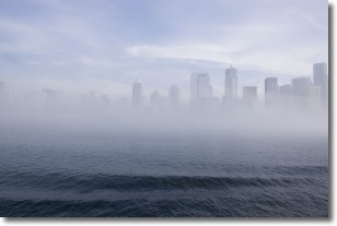
Weather Topic: What is Fog?
Home - Education - Cloud Types - Fog
 Next Topic: Fractus Clouds
Fog is technically a type of stratus cloud, which lies along the
ground and obscures visibility.
It is usually created when humidity in the air condenses into tiny water droplets.
Because of this, some places are more prone to foggy weather, such as regions
close to a body of water.
Fog is similar to mist; both are the appearance of water droplets suspended in
the air, but fog is the term applied to the condition when visibility is less than 1 km.
Next Topic: Fractus Clouds
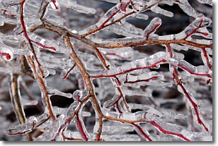
Weather Topic: What is Freezing Rain?
Home - Education - Precipitation - Freezing Rain
 Next Topic: Graupel
Freezing rain is a condition where precipitation which has fallen in the form of
water droplets reaches temperatures which are below freezing and freezes upon
coming into contact
with surface objects. The result of this precipitation is a glaze of ice which
can be damaging to plants and man-made structures. A severe onset of freezing
rain which results in a very thick glaze of ice is known as an ice storm.
Next Topic: Graupel
Current conditions powered by WeatherAPI.com


